Traffic Advisory
Committee MEETING
Notice
of Meeting
Thursday, 6 June 2013
Thursday, 30 May 2013
His
Worship The Mayor and Councillors
I
have by direction to inform you that a meeting of the Traffic Advisory Committee Meeting of the Council will be held at the Civic Centre Meeting Room 2,
on Thursday, 6 June 2013 for consideration of the business available on
Council's website at http://www.hurstville.nsw.gov.au/Agendas-and-Minutes.
Mr V G D Lampe
General Manager
BUSINESS
1. Apologies
2. Matters
Arising from Previous Meeting
3. Disclosures of Interest
4. Agenda
Items
5. General Business
6. Next meeting Thursday 04 July 2013 at 1:00pm
Traffic
Advisory Committee Meeting
Summary of Items
Thursday,
06 June 2013
Agenda Items
TAC064-13 Kingsgrove Traffic Study (12/558)
(Report by Senior Traffic Engineer,
Mrs S Selim)....................................................... 2
TAC065-13 Anderson Road Mortdale - Request for
Linemarking (13/487)
(Report by Senior Traffic Engineer,
Mrs S Selim)..................................................... 15
TAC066-13 Orange Street Hurstville - Road Safety
Concerns (10/1050)
(Report by Senior Traffic Engineer,
Mrs S Selim)..................................................... 17
TAC067-13 Cook Street and Ellen Subway Mortdale -
Request to upgrade the existing Give-Way restriction at the intersection to a
STOP restriction (10/1439)
(Report by Senior Traffic Engineer,
Mrs S Selim)..................................................... 19
TAC068-13 Gungah Bay Road Oately - Road Safety
Concerns (11/380)
(Report by Senior Traffic Engineer,
Mrs S Selim)..................................................... 22
TAC069-13 Penshurst Street Beverly Hills - Proposal
to Install a Bus Zone (10/963)
(Report by Senior Traffic Engineer,
Mrs S Selim)..................................................... 25
TAC070-13 Lily Lane Hurstville - Request for
Protective Barrier (11/288)
(Report by Senior Traffic Engineer,
Mrs S Selim)..................................................... 27
TAC071-13 Riley Street Oatley - Request for
Centreline Markings (10/1269)
(Report by Senior Traffic Engineer,
Mrs S Selim)..................................................... 30
TAC072-13 Patrick Street Hurstville - Road Safety
Concerns (10/1870)
(Report by Traffic Engineering
Officer, Miss A Kavanagh)...................................... 32
TAC073-13 Trafalgar Street Peakhurst - Request for
Speed Humps (12/2043)
(Report by Traffic Engineering
Officer, Miss A Kavanagh)...................................... 34
Hurstville City Council – Traffic Advisory Committee
Meeting Thursday, 6 June 2013
4. Agenda
Items
TAC064-13 Kingsgrove
Traffic Study
|
Report Author/s
|
Senior Traffic Engineer, Mrs S
Selim
|
|
File
|
12/558
|
|
Previous Reports Referenced
|
No
|
|
Community Strategic Plan Pillar
|
Social and Cultural Development
|
|
Existing Policy?
|
No
|
New Policy Required?
|
No
|
|
Financial Implications
|
Nil
|
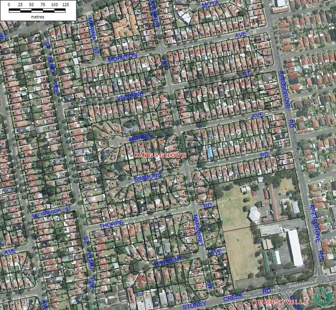
EXECUTIVE SUMMARY
This report is presented to the
Traffic Advisory Committee to report the findings of comprehensive traffic
surveys carried out for the local street network bounded by Stoney Creek Road,
Kingsgrove Road, St Elmo Parade and Morgan Street, Kingsgrove.
|
AUTHOR RECOMMENDATION
THAT the information as presented in the report be
received and noted
|
REPORT DETAIL
In light of a traffic accident
occurred late last year in Vivienne Street, Kingsgrove, Council received
numerous representations from residents and members of the community raising
road safety concerns around the local roads in Kingsgrove.
Council had a meeting with
Officers of the Roads and Maritime Services (RMS), Police and Rockdale City
Council to discuss this matter. In the meeting it was revealed that a
police report was still yet to be finalised and no comment could be provided
with regard to the cause of the accident.
To address the road safety
concerns raised by surrounding residents, the Traffic Committee in March 2013,
recommended:
“THAT
comprehensive traffic surveys for the local streets bounded by Stoney Creek
Road, Kingsgrove Road, St Elmo Parade and Morgan Street, Kingsgrove be carried
out for duration of two weeks.
THAT the
traffic section write to Rockdale City Council requesting them to carryout
similar counts for their side of the LGA to capture “rat runs” that occur
during morning and afternoon peak times.
FURTHER THAT
the findings of the surveys and accident history of the local streets bounded
by Stoney Creek Road, Kingsgrove Road, St Elmo Parade and Morgan Street,
Kingsgrove be reported back to Hurstville Traffic Advisory Committee for
consideration and recommendation.”
Council endorsed the Traffic
Advisory Committee’s recommendation.
Accordingly Council engaged a
traffic consultant to carry out required surveys for duration of two weeks to
collect necessary traffic counts and speed data to establish the traffic
situation in the precinct.
Traffic surveys were carried out
at 10 locations from 2 May 2013 till 16 May 2013. The locations were as
follows.
1. Marina Street,
Kingsgrove between Moreton Avenue to Morgan Street, Kingsgrove.
2. Moreton Avenue,
Kingsgrove between Cul de Sac to Kingsgrove Road (between Marina Street and
Margaret Street, outside house no 34)
3. Moreton Avenue
Kingsgrove between Cul de Sac to Kingsgrove Road (between Margaret Street and
Kingsgrove Road, outside house no 18)
4. Vivienne Street,
Kingsgrove between St Elmo Parade to Kingsgrove Road (between Margaret Street
and Kingsgrove Road, outside house No 5)
5. Morris Avenue,
Kingsgrove between the Cul de Sac and Kingsgrove Road (between Margaret Street
and Kingsgrove Road, outside house No 13)
6. Simmons Road,
Kingsgrove between Cul de Sac to Kingsgrove Road(between Margaret Street and
Kingsgrove Road, outside house no 17)
7. Thorpe Road,
Kingsgrove between St Elmo Parade to Kingsgrove School (between St Elmo Parade
and Margaret Street, outside house no 13)
8. Margaret Street,
Kingsgrove, between Stoney Creek Road to Morgan Street(between Thorpe road and
Simmons Road, outside house no 21)
9. Margaret Street,
Kingsgrove between Stoney Creek Road to Morgan Street (between Moreton Avenue
and Morgan Street, outside house no 51)
10. Margaret Street, Kingsgrove
between Stoney Creek Road to Morgan Street (between Stoney Creek Road and
Rayment Avenue, outside house no 5)
Results of the surveys are tabulated and presented for the
Committee to review.
Results of the
comprehensive Traffic Surveys
Marina Street, Kingsgrove, between Moreton Avenue to
Morgan Street, Kingsgrove.
Week 1
|
Marina Street
|
Northbound
|
Southbound
|
Combined
|
|
50%ile Speed (km/h)
|
34km/h
|
31km/h
|
33km/h
|
|
85%ile Speed (km/h)
|
42km/h
|
39km/h
|
40km/h
|
|
5 day AADT (veh per day)
|
154 vehicles
|
120 vehicles
|
274 vehicles
|
|
7 day AADT (veh per day)
|
132 vehicles
|
106 vehicles
|
238 vehicles
|
|
Time of most vehicles recorded AM
|
8am-9am (5 days
Average of 25 vehicles)
|
8am-9am (5 days
average of 27 vehicles)
|
8am-9am (5 days
average of 52 vehicles)
|
|
Time of most vehicles recorded PM
|
3pm-4pm (5 days
Average of 33 vehicles
|
3pm-4pm(5 days
average of 10 vehicles)
|
3pm-4pm(5 days
average of 43 vehicles)
|
Week 2
|
Marina Street
|
Northbound
|
Southbound
|
Combined
|
|
50%ile Speed (km/h)
|
35km/h
|
31km/h
|
33km/h
|
|
85%ile Speed (km/h)
|
43km/h
|
38km/h
|
40km/h
|
|
5 day AADT (veh per day)
|
143 vehicles
|
94 vehicles
|
237 vehicles
|
|
7 day AADT (veh per day)
|
125 vehicles
|
90 vehicles
|
215 vehicles
|
|
Time of most vehicles recorded AM
|
8am-9am (5 days Average
of 24 vehicles)
|
8am-9am (5 days
average of 14 vehicles)
|
8am-9am (5 days
average of 37 vehicles)
|
|
Time of most vehicles recorded PM
|
3pm-4pm (5 days
average of 29 vehicles
|
5pm-6pm(5 days
average of 9 vehicles)
|
3pm-4pm(5 days
average of 37 vehicles)
|
Moreton Avenue, Kingsgrove between Cul de Sac to
Kingsgrove Road (between Marina Street and Margaret Street, outside house no
34)
Week 1
|
Moreton Avenue
|
Eastbound
|
Westbound
|
Combined
|
|
50%ile Speed (km/h)
|
34km/h
|
35km/h
|
35km/h
|
|
85%ile Speed (km/h)
|
41km/h
|
45km/h
|
44km/h
|
|
5 day AADT (veh per day)
|
128 vehicles
|
167 vehicles
|
295 vehicles
|
|
7 day AADT (veh per day)
|
112 vehicles
|
142 vehicles
|
254 vehicles
|
|
Time of most vehicles recorded AM
|
8am-9am (5 days
Average of 30 vehicles)
|
8am-9am (5 days
average of 24 vehicles)
|
8am-9am (5 days
average of 53 vehicles)
|
|
Time of most vehicles recorded PM
|
3pm-4pm (5 days
Average of 10 vehicles
|
3pm-4pm(5 days
average of 35 vehicles)
|
3pm-4pm(5 days
average of 45 vehicles)
|
Week 2
|
Moreton Avenue
|
Eastbound
|
Westbound
|
Combined
|
|
50%ile Speed (km/h)
|
33km/h
|
36km/h
|
35km/h
|
|
85%ile Speed (km/h)
|
40km/h
|
46km/h
|
44km/h
|
|
5 day AADT (veh per day)
|
104 vehicles
|
157 vehicles
|
260 vehicles
|
|
7 day AADT (veh per day)
|
97 vehicles
|
136 vehicles
|
233 vehicles
|
|
Time of most vehicles recorded AM
|
8am-9am (5 days
Average of 16 vehicles)
|
8am-9am (5 days
average of 22 vehicles)
|
8am-9am (5 days
average of 38 vehicles)
|
|
Time of most vehicles recorded PM
|
3pm-4pm (5 days
Average of 11 vehicles
|
3pm-4pm(5 days
average of 32 vehicles)
|
3pm-4pm(5 days
average of 41 vehicles)
|
Moreton Avenue Kingsgrove between Cul de Sac to
Kingsgrove Road (between Margaret Street and Kingsgrove Road, outside house no
18)
Week 1
|
Moreton Avenue
|
Eastbound
|
Westbound
|
Combined
|
|
50%ile Speed (km/h)
|
42km/h
|
42km/h
|
42km/h
|
|
85%ile Speed (km/h)
|
49km/h
|
49km/h
|
49km/h
|
|
5 day AADT (veh per day)
|
573 vehicles
|
429 vehicles
|
1002 vehicles
|
|
7 day AADT (veh per day)
|
479 vehicles
|
364 vehicles
|
843 vehicles
|
|
Time of most vehicles recorded AM
|
8am-9am (5 days
Average of154 vehicles)
|
8am-9am (5 days
average of 39 vehicles)
|
8am-9am (5 days
average of 193 vehicles)
|
|
Time of most vehicles recorded PM
|
3pm-4pm (5 days
Average of 41 vehicles
|
3pm-4pm(5 days
average of 76 vehicles)
|
3pm-4pm(5 days
average of 117 vehicles)
|
Week 2
|
Moreton Avenue
|
Eastbound
|
Westbound
|
Combined
|
|
50%ile Speed (km/h)
|
42km/h
|
42km/h
|
42km/h
|
|
85%ile Speed (km/h)
|
49km/h
|
49km/h
|
49km/h
|
|
5 day AADT (veh per day)
|
510 vehicles
|
427 vehicles
|
937 vehicles
|
|
7 day AADT (veh per day)
|
436 vehicles
|
369 vehicles
|
805 vehicles
|
|
Time of most vehicles recorded AM
|
8am-9am (5 days
Average of 107 vehicles)
|
8am-9am (5 days
average of 38 vehicles)
|
8am-9am (5 days
average of 146 vehicles)
|
|
Time of most vehicles recorded PM
|
3pm-4pm (5 days
average of 35 vehicles
|
5pm-6pm(5 days
average of 79 vehicles)
|
3pm-4pm(5 days
average of 114 vehicles)
|
Vivienne Street, Kingsgrove between St Elmo Parade to
Kingsgrove Road (between Margaret Street and Kingsgrove Road, outside house No
5)
Week 1
|
Vivienne Street
|
Eastbound
|
Westbound
|
Combined
|
|
50%ile Speed (km/h)
|
42km/h
|
38km/h
|
41km/h
|
|
85%ile Speed (km/h)
|
50km/h
|
48km/h
|
49km/h
|
|
5 day AADT (veh per day)
|
594 vehicles
|
368 vehicles
|
962 vehicles
|
|
7 day AADT (veh per day)
|
500 vehicles
|
339 vehicles
|
839 vehicles
|
|
Time of most vehicles recorded AM
|
8am-9am (5 days
Average of 196 vehicles)
|
8am-9am (5 days
average of 33 vehicles)
|
8am-9am (5 days
average of 229 vehicles)
|
|
Time of most vehicles recorded PM
|
3pm-4pm (5 days
Average of 43 vehicles
|
3pm-4pm(5 days
average of 67 vehicles)
|
3pm-4pm(5 days
average of 110 vehicles)
|
Week 2
|
Vivienne Street
|
Eastbound
|
Westbound
|
Combined
|
|
50%ile Speed (km/h)
|
42km/h
|
39km/h
|
41km/h
|
|
85%ile Speed (km/h)
|
50km/h
|
48km/h
|
49km/h
|
|
5 day AADT (veh per day)
|
571 vehicles
|
365 vehicles
|
935 vehicles
|
|
7 day AADT (veh per day)
|
477 vehicles
|
334 vehicles
|
811 vehicles
|
|
Time of most vehicles recorded AM
|
8am-9am (5 days
Average of 173 vehicles)
|
8am-9am (5 days
average of 28 vehicles)
|
8am-9am (5 days
average of 201 vehicles)
|
|
Time of most vehicles recorded PM
|
3pm-4pm (5 days
average of 42 vehicles
|
5pm-6pm(5 days
average of 69 vehicles)
|
3pm-4pm(5 days
average of 111 vehicles)
|
Morris Avenue, Kingsgrove between the Cul de Sac and
Kingsgrove Road (between Margaret Street and Kingsgrove Road, outside house No
13)
Week 1
|
Morris Avenue
|
Eastbound
|
Westbound
|
Combined
|
|
50%ile Speed (km/h)
|
45km/h
|
43km/h
|
44km/h
|
|
85%ile Speed (km/h)
|
56km/h
|
53km/h
|
55km/h
|
|
5 day AADT (veh per day)
|
332 vehicles
|
201 vehicles
|
534 vehicles
|
|
7 day AADT (veh per day)
|
274 vehicles
|
179 vehicles
|
453 vehicles
|
|
Time of most vehicles recorded AM
|
8am-9am (5 days
Average of 110 vehicles)
|
8am-9am (5 days
average of 22 vehicles)
|
8am-9am (5 days
average of 132 vehicles)
|
|
Time of most vehicles recorded PM
|
3pm-4pm (5 days
Average of 25 vehicles)
|
3pm-4pm(5 days
average of 42 vehicles)
|
3pm-4pm(5 days
average of 67 vehicles)
|
Week 2
|
Morris Avenue
|
Eastbound
|
Westbound
|
Combined
|
|
50%ile Speed (km/h)
|
45km/h
|
43km/h
|
44km/h
|
|
85%ile Speed (km/h)
|
56km/h
|
53km/h
|
55km/h
|
|
5 day AADT (veh per day)
|
304 vehicles
|
193 vehicles
|
497 vehicles
|
|
7 day AADT (veh per day)
|
256 vehicles
|
177 vehicles
|
434 vehicles
|
|
Time of most vehicles recorded AM
|
8am-9am (5 days
Average of 96 vehicles)
|
8am-9am (5 days
average of 19 vehicles)
|
8am-9am (5 days
average of 115 vehicles)
|
|
Time of most vehicles recorded PM
|
3pm-4pm (5 days
average of 23 vehicles)
|
5pm-6pm(5 days
average of 40 vehicles)
|
3pm-4pm(5 days
average of 63 vehicles)
|
Simmons Road, Kingsgrove between Cul de Sac to Kingsgrove
Road(between Margaret Street and Kingsgrove Road, outside house no 17)
Week 1
|
Simmons Road
|
Eastbound
|
Westbound
|
Combined
|
|
50%ile Speed (km/h)
|
42km/h
|
41km/h
|
42km/h
|
|
85%ile Speed (km/h)
|
51km/h
|
50km/h
|
50km/h
|
|
5 day AADT (veh per day)
|
442 vehicles
|
462 vehicles
|
904 vehicles
|
|
7 day AADT (veh per day)
|
362 vehicles
|
408 vehicles
|
771 vehicles
|
|
Time of most vehicles recorded AM
|
8am-9am (5 days
Average of 136 vehicles)
|
8am-9am (5 days
average of 69 vehicles)
|
8am-9am (5 days
average of 205 vehicles)
|
|
Time of most vehicles recorded PM
|
3pm-4pm (5 days
Average of 27 vehicles)
|
3pm-4pm(5 days average
of 90 vehicles)
|
3pm-4pm(5 days
average of 117 vehicles)
|
Week 2
|
Simmons Road
|
Eastbound
|
Westbound
|
Combined
|
|
50%ile Speed (km/h)
|
42km/h
|
41km/h
|
41km/h
|
|
85%ile Speed (km/h)
|
50km/h
|
49km/h
|
50km/h
|
|
5 day AADT (veh per day)
|
416 vehicles
|
459 vehicles
|
875 vehicles
|
|
7 day AADT (veh per day)
|
345 vehicles
|
410 vehicles
|
756 vehicles
|
|
Time of most vehicles recorded AM
|
8am-9am (5 days
Average of 126 vehicles)
|
8am-9am (5 days
average of 70 vehicles)
|
8am-9am (5 days
average of 196 vehicles)
|
|
Time of most vehicles recorded PM
|
3pm-4pm (5 days
average of 24 vehicles)
|
5pm-6pm(5 days
average of 91 vehicles)
|
3pm-4pm(5 days
average of 115 vehicles)
|
Thorpe Road, Kingsgrove between St Elmo Parade to
Kingsgrove School (between St Elmo Parade and Margaret Street, outside house no
13)
Week 1
|
Thorpe Road
|
Eastbound
|
Westbound
|
Combined
|
|
50%ile Speed (km/h)
|
37km/h
|
35km/h
|
36km/h
|
|
85%ile Speed (km/h)
|
48km/h
|
46km/h
|
47km/h
|
|
5 day AADT (veh per day)
|
322 vehicles
|
247 vehicles
|
570 vehicles
|
|
7 day AADT (veh per day)
|
258 vehicles
|
215 vehicles
|
473 vehicles
|
|
Time of most vehicles recorded AM
|
8am-9am (5 days
Average of 146 vehicles)
|
8am-9am (5 days
average of 49 vehicles)
|
8am-9am (5 days
average of 195 vehicles)
|
|
Time of most vehicles recorded PM
|
3pm-4pm (5 days
Average of 20 vehicles)
|
3pm-4pm(5 days
average of 49 vehicles)
|
3pm-4pm(5 days
average of 70 vehicles)
|
Week 2
|
Simmons Road
|
Eastbound
|
Westbound
|
Combined
|
|
50%ile Speed (km/h)
|
38km/h
|
35km/h
|
36km/h
|
|
85%ile Speed (km/h)
|
48km/h
|
45km/h
|
47km/h
|
|
5 day AADT (veh per day)
|
308 vehicles
|
245 vehicles
|
553 vehicles
|
|
7 day AADT (veh per day)
|
245 vehicles
|
216 vehicles
|
462 vehicles
|
|
Time of most vehicles recorded AM
|
8am-9am (5 days
Average of 136 vehicles)
|
8am-9am (5 days
average of 49 vehicles)
|
8am-9am (5 days
average of 185 vehicles)
|
|
Time of most vehicles recorded PM
|
3pm-4pm (5 days
average of 22 vehicles)
|
5pm-6pm(5 days
average of 50 vehicles)
|
3pm-4pm(5 days
average of 73 vehicles)
|
Margaret Street, Kingsgrove, between Stoney Creek Road to
Morgan Street(between Thorpe road and Simmons Road, outside house no 21)
Week 1
|
Margaret Street (No21)
|
Northbound
|
Southbound
|
Combined
|
|
50%ile Speed (km/h)
|
38km/h
|
39km/h
|
39km/h
|
|
85%ile Speed (km/h)
|
49km/h
|
49km/h
|
49km/h
|
|
5 day AADT (veh per day)
|
814 vehicles
|
985 vehicles
|
1798 vehicles
|
|
7 day AADT (veh per day)
|
689 vehicles
|
912 vehicles
|
1601 vehicles
|
|
Time of most vehicles recorded AM
|
8am-9am (5 days
Average of 209 vehicles)
|
8am-9am (5 days
average of 120 vehicles)
|
8am-9am (5 days
average of 329 vehicles)
|
|
Time of most vehicles recorded PM
|
3pm-4pm (5 days
Average of 69 vehicles)
|
3pm-4pm(5 days
average of 137 vehicles)
|
3pm-4pm(5 days
average of 206 vehicles)
|
Week 2
|
Margaret Street (No21)
|
Northbound
|
Southbound
|
Combined
|
|
50%ile Speed (km/h)
|
39km/h
|
40km/h
|
39km/h
|
|
85%ile Speed (km/h)
|
49km/h
|
50km/h
|
50km/h
|
|
5 day AADT (veh per day)
|
790 vehicles
|
982 vehicles
|
1771 vehicles
|
|
7 day AADT (veh per day)
|
667 vehicles
|
921 vehicles
|
1589 vehicles
|
|
Time of most vehicles recorded AM
|
8am-9am (5 days
Average of 197 vehicles)
|
8am-9am (5 days average
of 122 vehicles)
|
8am-9am (5 days
average of 319 vehicles)
|
|
Time of most vehicles recorded PM
|
3pm-4pm (5 days
average of 74 vehicles)
|
5pm-6pm(5 days
average of 142 vehicles)
|
3pm-4pm(5 days
average of 242 vehicles)
|
Margaret Street, Kingsgrove between Stoney Creek Road to
Morgan Street (between Moreton Avenue and Morgan Street, outside house no 51)
Week 1
|
Margaret Street (No51)
|
Northbound
|
Southbound
|
Combined
|
|
50%ile Speed (km/h)
|
38km/h
|
37km/h
|
37km/h
|
|
85%ile Speed (km/h)
|
47km/h
|
47km/h
|
47km/h
|
|
5 day AADT (veh per day)
|
657vehicles
|
1241 vehicles
|
1898 vehicles
|
|
7 day AADT (veh per day)
|
581vehicles
|
1098 vehicles
|
1679 vehicles
|
|
Time of most vehicles recorded AM
|
8am-9am (5 days
Average of 74 vehicles)
|
8am-9am (5 days
average of 268 vehicles)
|
8am-9am (5 days
average of 342 vehicles)
|
|
Time of most vehicles recorded PM
|
3pm-4pm (5 days
Average of 102 vehicles)
|
3pm-4pm(5 days
average of 92 vehicles)
|
3pm-4pm(5 days
average of 194 vehicles)
|
Week 2
|
Margaret Street (No51)
|
Northbound
|
Southbound
|
Combined
|
|
50%ile Speed (km/h)
|
38km/h
|
37km/h
|
38km/h
|
|
85%ile Speed (km/h)
|
48km/h
|
47km/h
|
47km/h
|
|
5 day AADT (veh per day)
|
654 vehicles
|
1171 vehicles
|
1825 vehicles
|
|
7 day AADT (veh per day)
|
584 vehicles
|
1055 vehicles
|
1640 vehicles
|
|
Time of most vehicles recorded AM
|
8am-9am (5 days
Average of 69 vehicles)
|
8am-9am (5 days
average of 215 vehicles)
|
8am-9am (5 days
average of 285 vehicles)
|
|
Time of most vehicles recorded PM
|
3pm-4pm (5 days
average of 117 vehicles)
|
5pm-6pm(5 days
average of 89 vehicles)
|
3pm-4pm(5 days
average of 206 vehicles)
|
Margaret Street, Kingsgrove between Stoney Creek Road to
Morgan Street (between Stoney Creek Road and Rayment Avenue, outside house no
5)
Week 1
|
Margaret Street (No5)
|
Northbound
|
Southbound
|
Combined
|
|
50%ile Speed (km/h)
|
28km/h
|
31km/h
|
29km/h
|
|
85%ile Speed (km/h)
|
36km/h
|
48km/h
|
37km/h
|
|
5 day AADT (veh per day)
|
456vehicles
|
710 vehicles
|
1166 vehicles
|
|
7 day AADT (veh per day)
|
400vehicles
|
670 vehicles
|
1069 vehicles
|
|
Time of most vehicles recorded AM
|
7am-8am (5 days
Average of 79 vehicles)
|
8am-9am (5 days
average of 73 vehicles)
|
8am-9am (5 days
average of 136 vehicles)
|
|
Time of most vehicles recorded PM
|
3pm-4pm (5 days
Average of 36 vehicles)
|
3pm-4pm(5 days
average of 97 vehicles)
|
3pm-4pm(5 days
average of 133 vehicles)
|
Week 2
|
Margaret Street (No5)
|
Northbound
|
Southbound
|
Combined
|
|
50%ile Speed (km/h)
|
27km/h
|
37km/h
|
30km/h
|
|
85%ile Speed (km/h)
|
36km/h
|
47km/h
|
37km/h
|
|
5 day AADT (veh per day)
|
457 vehicles
|
1171 vehicles
|
1170 vehicles
|
|
7 day AADT (veh per day)
|
399 vehicles
|
1055 vehicles
|
1082 vehicles
|
|
Time of most vehicles recorded AM
|
7am-8am (5 days
Average of 79 vehicles)
|
8am-9am (5 days
average of 215 vehicles)
|
8am-9am (5 days
average of 133 vehicles)
|
|
Time of most vehicles recorded PM
|
3pm-4pm (5 days
average of 39 vehicles)
|
5pm-6pm(5 days
average of 89 vehicles)
|
3pm-4pm(5 days
average of 139 vehicles)
|
An analysis of above results shows that there is no evidence
of speeding problems in the study area. The above results also show that the
hours of most traffic to frequent this area is mostly from 8am-9am and from
3pm-4pm, which are morning and afternoon peak times.
While it can be
concluded that these local streets are being used as a "rat run"
during morning and afternoon hours, it is advised that the counts are mostly
within the recommended environmental goals for a local road.
It is further
advised that these local roads, even though they are not intended for main
stream traffic they act as a "relief" mechanism, when traffic is
congested along Stoney Creek Road and Kingsgrove Road.
Hurstville City Council – Traffic Advisory Committee
Meeting Thursday, 6 June 2013
TAC065-13 Anderson Road Mortdale - Request for
Linemarking
|
Report Author/s
|
Senior Traffic Engineer, Mrs S
Selim
|
|
File
|
13/487
|
|
Previous Reports Referenced
|
No
|
|
Community Strategic Plan Pillar
|
Social and Cultural Development
|
|
Existing Policy?
|
No
|
New Policy Required?
|
No
|
|
Financial Implications
|
Within Budget
|
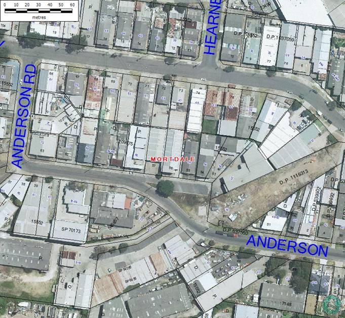
EXECUTIVE SUMMARY
Council has received a
representation from Chilled Air Pty Ltd factory located at 52 Anderson Road,
Mortdale, requesting Council to consider painting parking bays at the existing angle
parking zone in Anderson Road, Mortdale opposite the factory.
|
AUTHOR
RECOMMENDATION
THAT the existing angle parking
zone in Anderson Road Mortdale opposite 52 to 60 Anderson Road, Mortdale be
line-marked to provide formal parking bays to comply with Australian
Standards AS2890.1.
THAT the proposed line marking
works be included in Council’s Signs & Line Marking Works Program to fund
in 2013-2014 Financial Year.
FURTHER THAT Chilled Air Pty
Ltd at 52 Anderson Road, Mortdale be advised of Council’s decision.
|
REPORT DETAIL
Council has received a
representation from Chilled Air Pty Ltd factory located at 52 Anderson Road,
Mortdale, requesting Council to consider painting parking bays at the existing
angle parking zone in Anderson Road, Mortdale opposite the factory.
Anderson Road, Mortdale
branches-off at 62 Anderson Road creating an access road off the main
thoroughfare to service properties from 52 to 60 Anderson Road, Mortdale. Land
uses of these properties include light industries and industrial offices.
There is an angle parking zone in this section of Anderson Road, which is
utilised by the staff and visitors of the adjoining properties (52 to 60
Anderson Road, Mortdale).
A representative of Chilled Air
Pty Ltd at 52 Anderson Road, Mortdale has approached Council requesting Council
to consider linemarking the 90 degree angle parking bays to regulate this
parking zone claiming that it will improve the amount of parking spaces
available at this location by forcing cars to park within the parking bays.
It is advised that a site
inspection has revealed that the subject angle parking zone has been utilised
efficiently and that cars are parked within an appropriate distance of each
other.
Nevertheless, it is considered
appropriate to install 90 degree angle parking bays in accordance with
Australian Standards AS2890.1 at this location, subject to availability of
funding.
Hurstville City Council – Traffic Advisory Committee
Meeting Thursday, 6 June 2013
TAC066-13 Orange Street Hurstville - Road Safety
Concerns
|
Report Author/s
|
Senior Traffic Engineer, Mrs S
Selim
|
|
File
|
10/1050
|
|
Previous Reports Referenced
|
No
|
|
Community Strategic Plan Pillar
|
Social and Cultural Development
|
|
Existing Policy?
|
No
|
New Policy Required?
|
No
|
|
Financial Implications
|
Nil
|
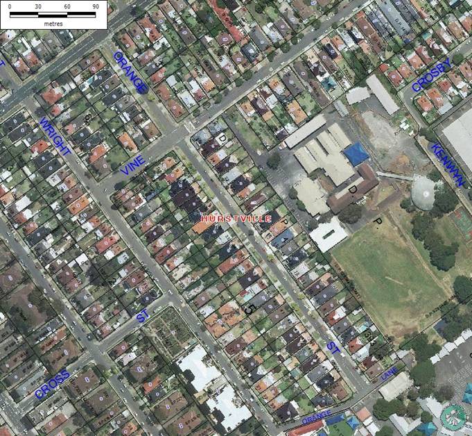
EXECUTIVE SUMMARY
Councillor Jack Jacovou, Mayor of
Hurstville City Council, on behalf of a resident in Orange Street, Hurstville
has made a representation requesting Council’s Traffic Section to investigate
resident’s road safety concerns around Hurstville Public School.
|
AUTHOR
RECOMMENDATION
THAT the illegal driver
behaviour be referred to Council’s law enforcement officers to enforce Road
Rules in Orange Street, especially around school drop off and pick up times.
FURTHER THAT the resident be
advised of Council’s decision.
|
REPORT DETAIL
Councillor Jack Jacovou, Mayor of
Hurstville City Council, on behalf of a resident in Orange Street, Hurstville
has made a representation requesting Council’s Traffic Section to investigate
resident’s road safety concerns around Hurstville Public School.
It is advised that Hurstville
Public School has an access facilitated from Orange Street, Hurstville whereby
many parents use this street to drop off and pick up their children.
The resident has advised Council
that on 09/05/2013, a parent crashed his vehicle into the front brick fence of
their property, while desperately trying to find a parking space to pick-up his
child. The resident has advised the above motorist has driven onto the front
lawn of their property and accidentally pressed the accelerator instead of the
break, crashing into the front fence.
Accordingly, the resident has
written to Council complaining that the traffic condition in Orange Street
during school time is extremely bad and can sometimes get out of control. The
resident has further advised that the situation is further exasperated by
illegal driver behaviour of some parents, such as parking on the footpath,
making illegal u-turns and double parking endangering the safety of
pedestrians, adjoining property owners and other road users.
The resident has requested
Council to reconsider the alternative of converting Orange Street, Hurstville
into a one-way street.
It is advised that the traffic
situation in Orange Street has been considered by the Traffic Advisory
Committee on many occasions in the past, with the latest time being in July
2012.
Converting Orange Street into a
one-way street was one of the options considered by the Traffic Advisory
Committee and was denied as the most of the residents in Orange Street and
other neighbouring streets in the area were not in favour of the proposal.
It is advised that Orange Street
is a quiet residential street with very low traffic movements outside school
start and finishing times. It should be noted that the road safety concerns
raised by the resident last only about 30-minutes during morning and afternoon
school start and finishing times.
After reviewing all the
information presented, the Traffic Advisory Committee in the past has always
concluded that the traffic situation in Orange Street is not a unique situation
to that street and that it happens at every street where a school is located.
Accordingly the Traffic Committee
has always recommended that the Traffic concerns in Orange Street be referred
to Council’s law Enforcement officers to enforce the Road Rules.
Hurstville City Council – Traffic Advisory Committee
Meeting Thursday, 6 June 2013
TAC067-13 Cook Street and Ellen Subway Mortdale -
Request to upgrade the existing Give-Way restriction at the intersection to a
STOP restriction
|
Report Author/s
|
Senior Traffic Engineer, Mrs S
Selim
|
|
File
|
10/1439
|
|
Previous Reports Referenced
|
No
|
|
Community Strategic Plan Pillar
|
Social and Cultural Development
|
|
Existing Policy?
|
No
|
New Policy Required?
|
No
|
|
Financial Implications
|
Within Budget
|
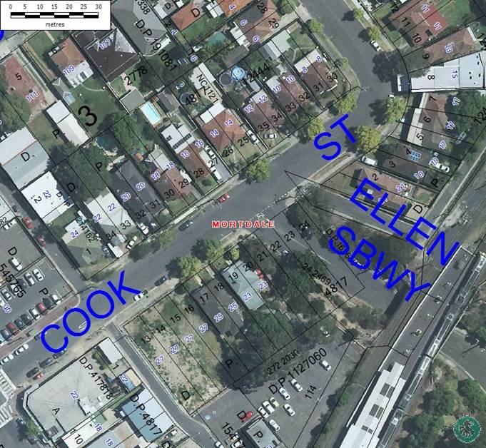
EXECUTIVE SUMMARY
Council has received a
representation from Mr Mark Coure, MP, Member for Oatley, on behalf of a
resident in Mortdale requesting Council to consider upgrading the Give-Way
restriction at the intersection of Cook Street and Ellen Subway, Mortdale to a
STOP restriction.
|
AUTHOR
RECOMMENDATION
THAT the request to upgrade the
existing Give-Way restriction at the intersection of Ellen Subway and Cook
Street, Mortdale to a STOP restriction be denied
THAT the Statutory No Stopping
restriction be installed in Ellen Subway at Cook Street, Mortdale.
FURTHER THAT Mr Mark Coure, MP,
Member for Oatley be advised of Council’s decision.
|
REPORT DETAIL
Council has received a
representation from Mr Mark Coure, MP, Member for Oatley, on behalf of a
resident in Mortdale requesting Council to consider upgrading the Give-Way
restriction at the intersection of Cook Street and Ellen Subway, Mortdale to a
STOP restriction.
The resident has raised concerns
regarding access to the off-street parking facility of his property alleging
that regularly motorists turning left from Ellen Subway into Cook Street ignore
the Give-Way restriction at the intersection of Ellen Subway and Cook Street,
Mortdale, making it difficult for him to exit his driveway located on Cook
Street.
The resident’s property at 23
Cook Street, Mortdale is located at the south-western corner of the
intersection of Cook Street and Ellen Subway, Mortdale. The vehicular crossing
of the subject property is about 2.8 metres wide and located in Cook Street
about 5 metres from the kerb-line of Ellen Subway, within the signposted
Statutory No Stopping restriction.
Currently a GIVE WAY restriction
exists at the intersection of Cook Street and Ellen Subway where traffic on
Ellen subway must give way to traffic travelling on Cook Street.
A review of the Roads and Traffic
Authority accident data shows, that only one accident has been reported during
the 5-year period between January 2007 and December 2011 at the intersection of
Ellen Subway at Cook Street. The accident occurred on 19 June 2010, where a
car travelling Northbound in Ellen Subway turning left into Cook Street had
collided with a car travelling west on Cook Street, Mortdale. However, no
accidents have been reported resulting from no compliance of the above GIVE WAY
restriction.
It is advised that the above
request was considered previously by the Traffic Committee in May 2008, where
the Traffic Committee recommended and Council endorsed;
“THAT the
tree branches near the ‘Give Way’ signs be trimmed to improve visibility of the
‘Give Way’ signs in Ellen Subway at Cook Street, Mortdale.
THAT the
statutory 10-metre ‘No Stopping’ restrictions be installed on all legs of the
intersection of Ellen Subway and Cook Street, Mortdale.
FURTHER
THAT the resident of 23 Cook Street be requested to reduce the height of the
side fence of his driveway.”
Accordingly the Traffic Section
wrote to the resident advising him of the above mentioned recommendation.
It is further advised that RMS
technical Directions stipulate that an intersection that is controlled by Give
Way restriction should be upgraded to a STOP restriction if site distance is
impeded at the intersection. Site inspection has revealed that with the
current signposted Statutory No Stopping restriction in Cook Street at its
intersection with Ellen Subway, Mortdale, there is sufficient sight distance
for vehicles on Ellen Subway to safely merge with traffic travelling in Cook
Street, Mortdale.
A site inspection has also
revealed that while the Statutory No Stopping restriction is installed in Cook
Street, Mortdale, it is not installed in Ellen Subway.
Accordingly it is recommended
that the Statutory No Stopping restriction be installed in Ellen Subway to
further enhance visibility at the subject intersection.
Hurstville City Council – Traffic Advisory Committee
Meeting Thursday, 6 June 2013
TAC068-13 Gungah Bay Road Oately - Road Safety Concerns
|
Report Author/s
|
Senior Traffic Engineer, Mrs S
Selim
|
|
File
|
11/380
|
|
Previous Reports Referenced
|
No
|
|
Community Strategic Plan Pillar
|
Social and Cultural Development
|
|
Existing Policy?
|
No
|
New Policy Required?
|
No
|
|
Financial Implications
|
Nil
|
EXECUTIVE SUMMARY
Council has received a
representation from Mr Mark Coure, MP, Member for Oatley on behalf of a
resident in Oatley raising road safety concerns along Gungah Bay Road between
Mulga Road and Lloyd Street, Oatley.
|
AUTHOR
RECOMMENDATION
THAT the request to upgrade the
existing pedestrian refuge in Gungah Bay Road at Mulga Road, Oatley to a
formal Pedestrian crossing be denied as it does not meet required RMS
warrants.
THAT “Watch for Pedestrians”
warning sign be installed in Lloyd Street and Douglas Haig Street, Oatley,
west of Gungah Bay Road to warn motorists about the pedestrian refuge and the
pedestrian crossing in Gungah Bay Road, Oatley.
THAT the request to relocate
the 50km/h speed sign in Oatley Park Avenue be referred to RMS for
consideration.
THAT a warning
sign be installed on the southern side of Mulga Road to alert westbound
traffic on Mulga Road advising to slow down and to warn about merging traffic
from the customer carpark of Coles Supermarket.
FURTHER THAT Mr Mark Coure, MP,
Member for Oatley be advised of Council’s decision.
|
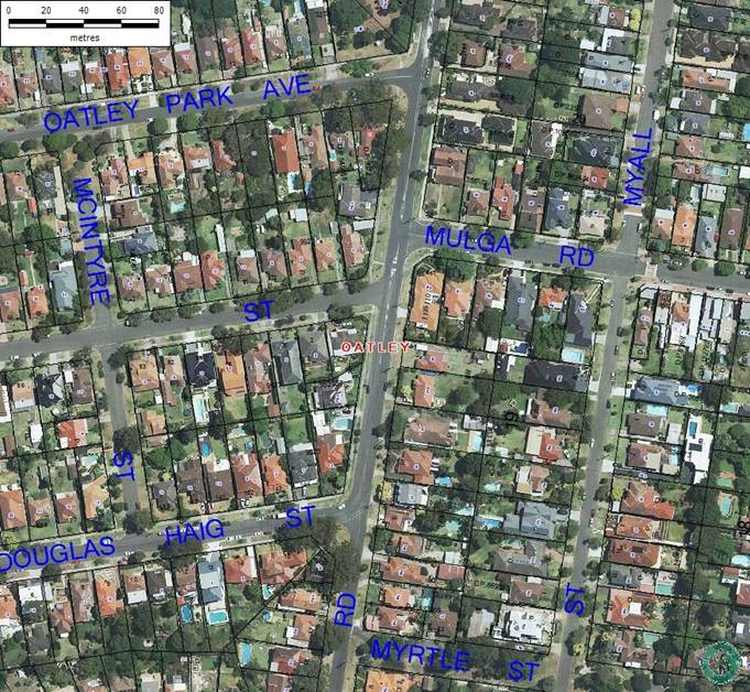
REPORT DETAIL
Council has received a
representation from Mr Mark Coure, MP, Member for Oatley on behalf of a
resident in Oatley raising road safety concerns along Gungah Bay Road between
Mulga Road and Lloyd Street, Oatley.
The
road safety concerns raised and some of the suggestions made by the resident to
improve road safety include:
· Upgrade the existing pedestrian refuge in Gungah Bay Rd at
Mulga Rd to a formal pedestrian crossing
· Increase signage on both approaches to Gungah Bay Road and
Douglas Haig Street alerting motorists that there are pedestrians and to
"slow down".
· A warning signs be installed in Lloyd Street, Oatley
alerting Refuge Island ahead.
· The existing 50km/h sign in Oatley Park Avenue be moved
closer to the intersection of Gungah Bay Road and Oatley Park Avenue.
· That cars exiting (coming up the ramp) from the underground
car park of Coles Supermarket in Mulga Rd have limited sight distances and thus
need appropriate signage to warn westbound traffic on Mulga Rd advising to slow
down and give way to merging traffic.
Upgrade
the existing pedestrian refuge in Gungah Bay Rd at Mulga Rd to a formal
pedestrian crossing
It is
advised that this request was considered in detail by the Traffic Advisory
Committee at its meeting in July 2012. After consideration of the information
presented including pedestrian and traffic counts at that location, the Traffic
Advisory Committee recommended and Council resolved in part
“THAT the request to upgrade the existing pedestrian refuge
in Gungah Bay Road, north of Lloyd Street, Oatley to a marked pedestrian
crossing be denied as it does not meet required RMS warrants for pedestrian
crossing.”
Increase signage on both approaches to Gungah Bay Road and
Douglas Haig Street alerting motorists that there are pedestrians and to
"slow down" and a warning signs be installed in Lloyd Street, Oatley
alerting Refuge Island ahead.
It is
advised that site inspection has revealed that there are signs in Gungah Bay
Road, warning motorists to the existence of the pedestrian refuge in Gungah Bay
Road near Lloyd Street and further signs in “Fluro” colour warning motorists to
the existence of the pedestrian crossing in Gungah Bay Road, Oatley, near
Oatley Park Avenue. Nevertheless, it is considered appropriate to install
further warning signs in Lloyd Street and Douglas Haig Street, Oatley, to alert motorists for the pedestrian crossing and
pedestrian refuge in Gungah Bay Road.
The existing 50km/h sign in Oatley Park Avenue be moved
closer to the intersection of Gungah Bay Road and Oatley Park Avenue.
It is
advised that speed zone signs are installed and maintained by the Roads and
Maritime Services (the RMS). Accordingly the resident’s request will be sent
to the RMS for review and appropriate action.
That
cars exiting (coming up the ramp) from the underground car park of Coles
Supermarket in Mulga Rd have limited sight distances and thus need appropriate
signage to warn westbound traffic on Mulga Rd advising to slow down and give
way to merging traffic
Site
inspection has revealed that there are two convex mirrors at the exit of the
car park onto Mulga Road to facilitate visibility of vehicles to Pedestrians
and vice versa. However, it is considered appropriate to install a warning
sign in Mulga Road to alert westbound traffic on Mulga Rd advising to slow down
and give way to merging traffic.
Hurstville City Council – Traffic Advisory Committee
Meeting Thursday, 6 June 2013
TAC069-13 Penshurst Street Beverly Hills - Proposal to
Install a Bus Zone
|
Report Author/s
|
Senior Traffic Engineer, Mrs S
Selim
|
|
File
|
10/963
|
|
Previous Reports Referenced
|
No
|
|
Community Strategic Plan Pillar
|
Social and Cultural Development
|
|
Existing Policy?
|
No
|
New Policy Required?
|
No
|
|
Financial Implications
|
Within Budget
|
EXECUTIVE SUMMARY
A representation has received
from Council’s Design Section requesting to establish a Bus Zone at the
existing Bus Stop outside the side frontage of 1 Fripp Street, Beverly Hills to
upgrade the Bus Stop to comply with the DDA standards and requirements.
|
AUTHOR
RECOMMENDATION
THAT the statutory No Stopping
restriction be installed in Penshurst Street, south of Fripp Crescent,
Beverly Hills.
THAT a 16m long Bus Zone be
installed in Penshurst Street, south of the above statutory No Stopping zone
adjoining the side boundary of 1 Fripp Crescent, Beverly Hills.
FURTHER THAT the Design
Engineer be advised of Council’s decision.
|
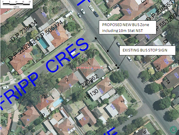
REPORT DETAIL
Council is currently upgrading
existing Bus Stops within Hurstville Local Government Area to comply with the
DDA requirements. The existing Bus Stop on a power pole in Penshurst Street at
the boundary between 195 Penshurst Street and 1 Fripp Crescent, Beverly Hills
is identified as one of the sites due for upgrade with the installation of a
concrete hardstand area to meet the DDA requirements. The current informal Bus
Zone extends along the side boundary of 1 Fripp Crescent and the frontages of
193 and 195 Penshurst Street, Beverly Hills.
Site inspections by Council’s
Design Engineer have indicated that the location of the existing Bus Stop at
this location is not suitable to provide a concrete hardstand area due to the
presence of a large stormwater drainage converter lid at that location.
Accordingly, it is recommended to
relocate the Bus Stop further north, closer to the intersection of Fripp
Crescent and Penshurst Street, Beverly Hill, by establishing a formal Bus Zone
to comply with the Road Rules.
It is advised that the proposed
Bus Zone could utilise the 10m Statutory No Stopping zone at the intersection
of Fripp Crescent and Penshurst Street, Penshurst, saving 10m of on street
parking. It is further advised that the Bus Zone will be installed wholly
within the side boundary of No 1 Fripp Street, and thus will not have any
adverse effect on amenities of adjoining property owners.
Once installed, the above Bus
Zone will measure 16 metres of signposted Bus Zone and 10m Statutory No
Stopping restriction. These measurements will limit the Bus Zone to be wholly
within the side boundary of 1 Fripp Crescent, Beverly Hills.
Hurstville City Council – Traffic Advisory Committee
Meeting Thursday, 6 June 2013
TAC070-13 Lily Lane Hurstville - Request for Protective
Barrier
|
Report Author/s
|
Senior Traffic Engineer, Mrs S
Selim
|
|
File
|
11/288
|
|
Previous Reports Referenced
|
No
|
|
Community Strategic Plan Pillar
|
Social and Cultural Development
|
|
Existing Policy?
|
No
|
New Policy Required?
|
No
|
|
Financial Implications
|
Nil
|
EXECUTIVE SUMMARY
Council has received a
representation from the owner of 89 Cronulla Street, Hurstville, requesting
Council to install bollards at the rear boundary of his property in Lily Lane.
|
AUTHOR
RECOMMENDATION
THAT the request for a
protective barrier to be installed in Lily Lane, Hurstville adjoining the
rear boundary of property at 89 Cronulla Street, Hurstville be denied.
FURTHER THAT the resident be
advised of Council’s decision.
|
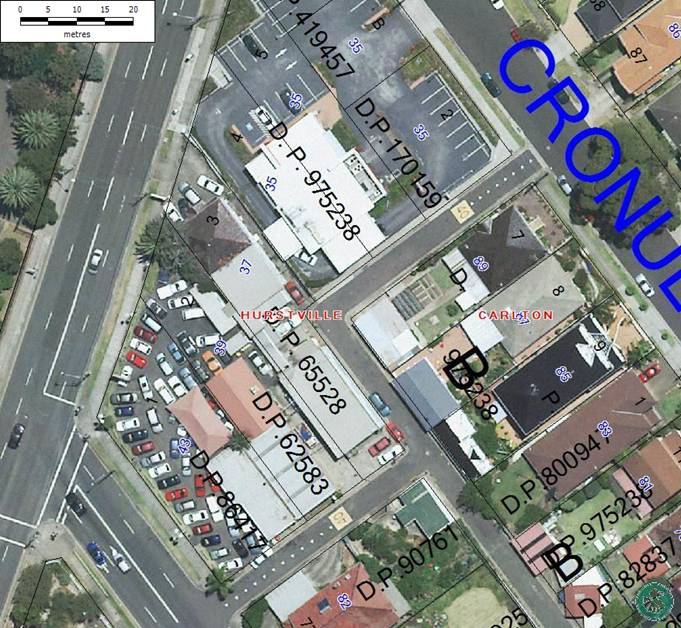
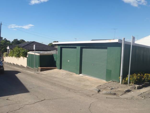
REPORT DETAIL
Council has received a
representation from the owner of 89 Cronulla Street, Hurstville, requesting
Council to install bollards or a guard rail at the rear boundary of his
property in Lily Lane. Lily Lane Hurstville measures approximately 4m in
width.
Accordingly, the resident has
complained that trucks accessing this section of Lily Lane regularly destroy
the kerb and gutter at the corner of his property, and on many occasions damage
the resident’s property as well.
Site inspection has revealed that
the kerb and gutter have been damaged and require substantial repairs.
It is further advised that there
is a construction site in progress at 39-43 Forest Road Hurstville, with an
access from Lily Lane. This site is directly opposite the property at 89
Cronulla Street, Hurstville and construction vehicles accessing the
construction site could have been a contributing factor for the abovementioned
damage to Council infrastructure and adjoining properties.
Council’s Asset Engineer was
consulted in regards to whether a guard rail would help to protect Council’s
assets. He advised the following:
“I don’t believe it will benefit Council and will in fact
become another asset that will be regularly damaged and require on-going
maintenance.”
In light of Council’s Asset
Engineer’s advice, it is recommended that the request for bollards or a guard
rail be denied.
Hurstville City Council – Traffic Advisory Committee
Meeting Thursday, 6 June 2013
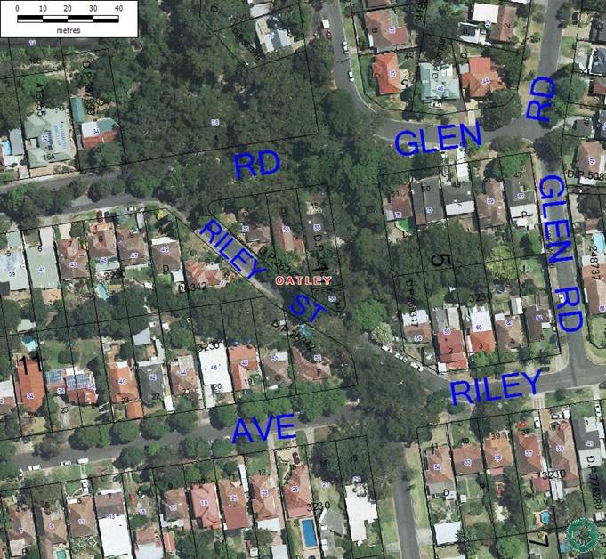
TAC071-13 Riley Street Oatley - Request for Centreline
Markings
|
Report Author/s
|
Senior Traffic Engineer, Mrs S
Selim
|
|
File
|
10/1269
|
|
Previous Reports Referenced
|
No
|
|
Community Strategic Plan Pillar
|
Social and Cultural Development
|
|
Existing Policy?
|
No
|
New Policy Required?
|
No
|
|
Financial Implications
|
Nil
|
EXECUTIVE SUMMARY
Councillor Philip Sansom has made
a representation on behalf of a resident in Oatley, requesting the Traffic
Section to consider installing centre line markings in Riley Street, Oatley.
|
AUTHOR
RECOMMENDATION
THAT the request for centre
line markings along the bends in Riley Street Oatley be denied.
FURTHER THAT Councillor Philip
Sansom be advised of Council’s decision.
|
REPORT DETAIL
Councillor Philip Sansom has made
a representation on behalf of a resident in Oatley, requesting the Traffic
Section to consider installing centre line markings in Riley Street, Oatley.
The resident believes that centre
line markings will improve road safety by assisting motorists to keep to the
left of the carriageway when driving around the bend along Riley Street,
Oatley.
It is advised that this section
of Riley Street is approximately 6.2m wide, with no parking restrictions on
either side of the street. Accordingly, if centre line markings are installed
along the carriageway, No Stopping restrictions will need to be installed on
both the northern and southern sides of Riley Street to comply with the Road
Rules. The Road Rules stipulate that it is required to leave minimum of 3m
space between the parked vehicles and double centre lines of a public road to
allow unhindered access for through traffic; however this could not be achieved
in Riley Street, Oatley, if the double centre lines are installed.
Site inspection has revealed that
many residents utilise the on street parking outside their premises for parking
their vehicles; thus installation of No Stopping restrictions would not result
in a favourable outcome for the residents of Riley Street, Oatley.
Hurstville City Council – Traffic Advisory Committee
Meeting Thursday, 6 June 2013
TAC072-13 Patrick Street Hurstville - Road Safety
Concerns
|
Report Author/s
|
Traffic Engineering Officer, Miss A
Kavanagh
|
|
File
|
10/1870
|
|
Previous Reports Referenced
|
No
|
|
Community Strategic Plan Pillar
|
Economic Prosperity
|
|
Existing Policy?
|
No
|
New Policy Required?
|
No
|
|
Financial Implications
|
Nil
|
EXECUTIVE SUMMARY
Councillor Jack Jacovou, Mayor of
Hurstville City Council on behalf of one of the residents in Hurstville has
requested Council’s Traffic Section to investigate the resident’s concerns
regarding the high volume of heavy vehicles on Patrick Street, Hurstville.
|
AUTHOR
RECOMMENDATION
THAT the traffic data presented
in this report be received and noted.
FURTHER THAT a copy of
Council’s report with traffic data be forwarded to the resident for
information.
|
REPORT DETAIL
Councillor Jack Jacovou, Mayor of
Hurstville City Council on behalf of one of the residents in Hurstville has
requested Council’s Traffic Section to investigate the resident’s concerns
regarding the high volume of heavy vehicles on Patrick Street, Hurstville. The
resident claims that heavy vehicle operators use Patrick Street as a
thoroughfare to travel in between Stoney Creek Road and Queens Road,
Hurstville. He has raised specific attention to the high volume of heavy
vehicles on Patrick Street near Hurstville Oval.
To ascertain the traffic
situation of Patrick Street, a detail traffic survey was conducted in Patrick
Street, Hurstville (in the vicinity of Hurstville Oval) from Tuesday 23 April
to Tuesday 14 May. A summary of type of vehicles monitored during
the survey period is tabulated below:
|
Type of Vehicles (Class)
|
Number of vehicles (veh/day)
|
Percentage (%)
|
|
Class 1 – Bicycle or
Motorcycle
|
8
|
0.6%
|
|
Class 2 – Cars
|
1240
|
97.6%
|
|
Class 3 – Trailer, Caravan,
Boat
|
2
|
0.1%
|
|
Class 4 – Two axle truck or
mini bus
|
18
|
1.4%
|
|
Class 5 – Three axle truck
or bus
|
4
|
0.2%
|
|
Class 6 – Four axle rigid
truck
|
1
|
<0.1%
|
|
Class 7 and above – Three
Axle articulated (semi-trailers) and above
|
0
|
0%
|
Additionally, the following data was also collected for
Patrick Street, Hurstville:
|
|
Northbound
|
Southbound
|
Combined
|
|
AADT (Daily Traffic
Volume)
|
463 veh/day
|
809 veh/day
|
1272 veh/day
|
|
50%ile
|
35.0 km/h
|
37.6 km/h
|
36.7 km/h
|
|
85%ile
|
40.7 km/h
|
43.2 km/h
|
42.5 km/h
|
From the data tabulated above it is evident that the volume
of heavy vehicles accessing Patrick Street, Hurstville is less than 1% of the
total volume of traffic. Additionally, the results show that the total volume
of daily traffic on Patrick Street is well below the environmental goals set by
the RMS for a local street.
Hurstville City Council – Traffic Advisory Committee
Meeting Thursday, 6 June 2013
TAC073-13 Trafalgar Street Peakhurst - Request for Speed
Humps
|
Report Author/s
|
Traffic Engineering Officer, Miss A
Kavanagh
|
|
File
|
12/2043
|
|
Previous Reports Referenced
|
No
|
|
Community Strategic Plan Pillar
|
Economic Prosperity
|
|
Existing Policy?
|
No
|
New Policy Required?
|
No
|
|
Financial Implications
|
Nil
|
EXECUTIVE SUMMARY
Council has received a
representation from a resident of Peakhurst requesting Council to install speed
humps in Trafalgar Street, Peakhurst.
|
AUTHOR
RECOMMENDATION
THAT the request for installation of a speed humps in
Trafalgar Street, Peakhurst be denied.
FURTHER THAT the resident be advised of Council’s
decision.
|
REPORT DETAIL
Council has received a representation from a resident of
Peakhurst requesting Council to install a speed hump in Trafalgar Street,
Peakhurst to calm traffic in the street.
The resident claims that motorists use Trafalgar Street,
Peakhurst as a through road to commute between Forest Road and Riverwood
shops. Most of these motorists travel over the posted speed limit of 50km/h
threatening safety of local residents and other road users.
Accordingly, Council conducted a comprehensive traffic
survey in Trafalgar Street, Peakhurst to ascertain the resident’s concerns. The
results of the survey are tabulated below.
|
|
East
|
West
|
Combined
|
|
50%
|
48.2 km/h
|
45.9 km/h
|
46.9 km/h
|
|
85%ile
|
57.2 km/h
|
54.7 km/h
|
56.2 km/h
|
|
AADT
|
659
|
806
|
1466
|
From the above results it is evident that the average annual
daily traffic travelling along Trafalgar Street, Peakhurst is well below the
environmental goals set by the RMS for a local road, which is around 2000-3000
vehicles per day. Thus there is no through traffic problem.
The results also show 50% of the vehicles on Trafalgar
Street travel well below the posted speed limit of the street. More than 85% of
traffic on Trafalgar Street travel below 58km/h, which is marginally above the
posted speed limit of the street.
Additional analysis showed that 5.51% of vehicles travelling
Trafalgar Street Peakhurst exceed 60km/h and the average of these vehicles
travel at 64.48 km/h. Analysis showed that there is no specific time when the
vehicles are travelling above the speed limit; however the peak traffic flows
are monitored between 7:00am-9:00am, weekdays.
It is considered that the above results do not warrant the
installation of speed humps or any other traffic calming devices in Trafalgar
Street. However, it is considered appreciate to refer the detail speeding data
to the Local Area Command for enforcement.
5. General Business
6. Next
Meeting
Next Meeting Date Thursday 04 July 2013 at 1:00pm