Traffic Advisory
Committee MEETING
Notice
of Meeting
Thursday, 05 June 2014
Friday, 30 May 2014
His
Worship The Mayor and Councillors
I
have by direction to inform you that a Traffic
Advisory Committee Meeting will be
held at Meeting Room 2, on Thursday,
05 June 2014 for consideration of the
business available on Council's website at http://www.hurstville.nsw.gov.au/Agendas-and-Minutes.
Mr V G D Lampe
General Manager
BUSINESS
1. Apologies
2. Confirmation
of Minutes of Previous Meeting
3. Matters
Arising from Previous Meeting
4. Disclosures
of Interest
5 Agenda
Items
6. General
Business
7. Next
meeting Thursday 03 July 2014 at 1:00pm
Traffic
Advisory Committee Meeting
Summary of Items
Thursday,
05 June 2014
Previous Minutes
MINUTES: Traffic Advisory Committee Meeting - 01 May
2014 (12/2126)
Agenda Items
TAC055-14 Kingsgrove Commercial Centre - Changes to
existing traffic conditions (13/584)
(Report by Senior Traffic Engineer,
Mrs S Selim).................................................... 2
TAC056-14 Cairns Street Riverwood - Request for
extending No Stopping Restriction (10/2120)
(Report by Senior Traffic Engineer,
Mrs S Selim).................................................... 5
TAC057-14 Immarna Place, Penshurst - Request to
install a No Parking restriction (14/852)
(Report by Traffic Engineering
Officer, Miss A Kavanagh).................................... 7
TAC058-14 Tooronga Terrace Beverly Hills - request
for additional parking spaces. (14/763)
(Report by Senior Traffic Engineer,
Mrs S Selim).................................................... 9
TAC059-14 Kingsgrove Car Park Kingsgrove - request
for parking changes (14/380)
(Report by Senior Traffic Engineer,
Mrs S Selim).................................................. 12
TAC060-14 Macmahon Street Car Park - Request to
reserve parking spaces for Sydney Polynesian Forum (09/263)
(Report by Senior Traffic Engineer,
Mrs S Selim).................................................. 14
TAC061-14 Mulga Road Oatley - request for a loading
zone (12/1557)
(Report by Senior Traffic Engineer,
Mrs S Selim).................................................. 16
TAC062-14 Gloucester Road, Pearl Street and Millet
Street Hurstville - Request for delineated car spaces (11/729)
(Report by Traffic Engineering
Officer, Miss A Kavanagh).................................. 18
TAC063-14 Millett Street Hurstville - Request for 90
degree angled parking (11/729)
(Report by Traffic Engineering
Officer, Miss A Kavanagh).................................. 20
TAC064-14 Lugarno Lions Spring Festival 2014 -
Proposed Traffic Control Measures (14/898)
(Report by Traffic Engineering
Officer, Miss A Kavanagh).................................. 22
TAC065-14 Wonoona Parade Oatley - Request for a No
Parking restriction (13/1023)
(Report by Traffic Engineering
Officer, Miss A Kavanagh).................................. 24
TAC066-14 330-332 Forest Road Hurstville - Request
for Road Closure (14/35)
(Report by Traffic Engineering
Officer, Miss A Kavanagh).................................. 25
Hurstville City Council – Traffic Advisory Committee
Meeting Thursday, 5 June 2014
5. Agenda Items
TAC055-14 Kingsgrove Commercial Centre - Changes to
existing traffic conditions
|
Report Author/s
|
Senior Traffic Engineer, Mrs S
Selim
|
|
File
|
13/584
|
|
Previous Reports Referenced
|
No
|
|
Community Strategic Plan Pillar
|
Social and Cultural Development
|
|
Existing Policy?
|
No
|
New Policy Required?
|
No
|
|
Financial Implications
|
Within Budget
|
EXECUTIVE SUMMARY
Councillor Badalati has made a
representation on behalf of the residents of Kingsgrove requesting to
investigate possible traffic management measures to ease traffic congestion
along Kingsgrove Road, Kingsgrove.
|
AUTHOR RECOMMENDATION
THAT the proposed traffic
management measures to improve traffic flow along Kingsgrove Road at Paterson
Avenue, Kingsgrove be received and noted.
THAT a traffic consultant be
engaged to undertake necessary modelling to examine the potential impact of
the proposed traffic management measures on the road network as well as the
level of services of the affected intersections.
THAT the finding of the
proposed study be reported to the Traffic Advisory Committee for
consideration.
THAT funding for the proposed
study be allocated from the 2015-2016 LATM budget.
FURTHER THAT Councillor
Badalati be advised of Council’s decision.
|
REPORT DETAIL
Councillor Badalati has made a
representation on behalf of the residents of Kingsgrove requesting to
investigate possible traffic management measures to ease traffic congestion
along Kingsgrove Road, Kingsgrove.
Kingsgrove Road is a regional
road which runs in a north-south direction between Canterbury Road and Stoney
Creek Road. It carries approximately 23,000 vehicles per day. Kingsgrove Road
is one of the boundaries between Rockdale City Council and Hurstville City
Council whereby the eastern side comes under the jurisdiction of Rockdale City
Council while the western side belongs to Hurstville City Council.
On the western side of Kingsgrove
Road, parking is not allowed between Paterson Avenue and Mashman Avenue to ease
traffic congestion at the intersection of Kingsgrove Road/Mashman Avenue/Shaw
Street. However, on the eastern side of Kingsgrove Road (Rockdale City
Council) between Paterson Avenue and Mashman Avenue a half an hour parking zone
operates between the hours of 9.00am and 3.00pm to facilitate parking for
shoppers leaving only one southbound lane for through southbound traffic. As a
result, southbound vehicles waiting for a gap to turn right from Kingsgrove
Road into Paterson Avenue hold all through southbound traffic on Kingsgrove
Road.
The traffic situation in Kingsgrove
Road was exacerbated when the two new mixed residential/commercial developments
in Mashman Avenue, Kingsgrove were opened as delivery vehicles and customer
vehicles of both these developments are accessed via Paterson Avenue and
Mashman Lane.
As a solution to improve traffic
flow in Kingsgrove Road, Hurstville City Council made a number of
representations to Rockdale City Council requesting to ban parking on the
eastern side of Kingsgrove Road between Mashman Avenue and Paterson Avenue (at
least during the morning peak period). However, Rockdale City Council refused
Hurstville City Council’s requests claiming that such a restriction will
adversely impact the adjoining business.
Accordingly, to ameliorate the
above scenario, Hurstville City Council installed a “No Right Turn, Emergency
Vehicles Excepted, 7:00am-3:30pm" restriction banning vehicles turning
right from Kingsgrove Road into Paterson Avenue, Kingsgrove to ease traffic
congestion along Kingsgrove Road. However, the residents have advised that the
above restriction is ignored by many motorists. Form 3:00pm to 7:00pm parking
on the eastern side of Kingsgrove Road (Rockdale City Council) is not allowed
to ease peak period traffic congestion.
To resolve this problem, Council
is proposing to construct a concrete median island in Kingsgrove Road at
Paterson Avenue to physically stop vehicles turning right from Kingsgrove Road
into Paterson Avenue, Kingsgrove. However, to ensure unhindered vehicular
access to the two new developments and reduce potential impacts on residential
properties in Colvin Avenue, Northcott Avenue and Mashman Avenue, the following
additional traffic management measures are proposed:
· Paterson Avenue between
Kingsgrove Road and Mashman Lane – retained the existing westbound one-way
direction to allow heavy vehicles and customer vehicles of the two new
developments to access from Kingsgrove Road, without affecting the residential
properties in Colvin Avenue.
· Paterson Avenue between
Colvin Avenue and Mashman Lane – reverse the existing one-way direction
allowing vehicles to travel eastbound only.
· Colvin Avenue between
Morgan Street and Paterson Avenue – reverse the existing one-way direction
allowing vehicles to travel northbound only.
· Provide a right turn bay
in Morgan Street at Colvin Avenue to reduce potential disruptions to through
traffic movements on Morgan Street.
· As a long-term measure,
investigate the possibility of changing the existing pedestrian activated
traffic lights at the intersection of Kingsgrove Road and Morgan Street to a
full signalised intersection to include traffic movements at this intersection
as well.
Current traffic
circulation is shown in the diagram below:
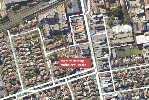
The proposed
traffic circulation is shown in the diagram below:

It is considered that the proposed measures will ease the
traffic congestion in Kingsgrove Road. However, it is recommended to engage a
traffic consultant to undertake necessary modelling to examine the potential
impact of the proposed changes on the road network as well as the level of
services of the affected intersections.
Hurstville City Council – Traffic Advisory Committee
Meeting Thursday, 5 June 2014
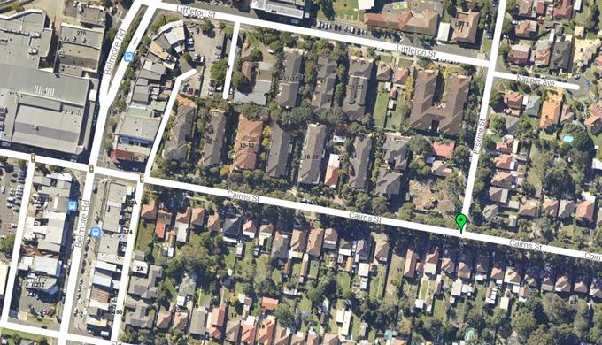
TAC056-14 Cairns Street Riverwood - Request for
extending No Stopping Restriction
|
Report Author/s
|
Senior Traffic Engineer, Mrs S
Selim
|
|
File
|
10/2120
|
|
Previous Reports Referenced
|
No
|
|
Community Strategic Plan Pillar
|
Social and Cultural Development
|
|
Existing Policy?
|
No
|
New Policy Required?
|
No
|
|
Financial Implications
|
Within Budget
|
EXECUTIVE SUMMARY
Council has received a
representation from a resident of Cairns Street, Riverwood requesting Council
to consider extending the existing No Stopping restriction on Cairns Street, at
its intersection with Erskine Street, Riverwood.
|
AUTHOR
RECOMMENDATION
THAT the existing No Stopping
restriction on the northern side of Cairns Street east of its intersection
with Erskine Street be extended to 15m.
FURTHER THAT the resident be
advised of Council’s decision.
|
REPORT DETAIL
Council has received a
representation from a resident of Cairns Street, Riverwood requesting Council
to consider extending the existing No Stopping restriction on Cairns Street, at
its intersection with Erskine Street, Riverwood.
The resident has advised that
since Council has installed the 2P restriction in Cairns Street between Belmore
Road and Erskine Street, parked vehicles have increased in Cairns Street,
between Erskine Street and Talbot Street, Riverwood. Accordingly the resident
has advised that due to the increased demand for parking in the street,
vehicles utilise every available space in the street for parking.
The intersection of Erskine
Street and Cairns Street is already signposted with the statutory, 10m No Stopping
restrictions; however the resident has requested Council to consider increasing
the length of the restriction to 15m. The resident believes that due to the
congestion of Cairns Street between Erskine and Talbot Street, the sight
distance of vehicles exiting Erskine Street to turn right onto Cairns street is
somewhat impaired by parked vehicles.
Site inspection has revealed that
indeed all available parking in Cairns Street between Erskine Street and Talbot
Street does get occupied by commuters. Accordingly, extending the existing No
Stopping restriction on the north eastern corner of Cairns Street at its
intersection with Erskine Street will improve sight distance for motorists
turning right from Erskine Street into Cairns street.
Hurstville City Council – Traffic Advisory Committee
Meeting Thursday, 5 June 2014
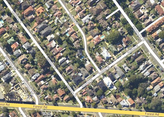
TAC057-14 Immarna Place, Penshurst - Request to install
a No Parking restriction
|
Report Author/s
|
Traffic Engineering Officer, Miss A
Kavanagh
|
|
File
|
14/852
|
|
Previous Reports Referenced
|
No
|
|
Community Strategic Plan Pillar
|
Economic Prosperity
|
|
Existing Policy?
|
No
|
New Policy Required?
|
No
|
|
Financial Implications
|
Within Budget.
|
EXECUTIVE SUMMARY
A representation has received
from Councillor Mining on behalf of one of the residents requesting Council to
consider installing a No Parking restriction on the north-eastern side of
Immarna Place from Rostrov Street to north of the driveway crossing at 4 Immarna
Place, Penshurst.
|
AUTHOR
RECOMMENDATION
THAT a 27 metre No Parking
restriction be installed on the north-eastern side of Immarna Place from
Rostrov Street to northern boundary of the driveway crossing at 4 Immarna
Place, Penshurst subject to consultation with the affected residents.
FURTHER THAT Councillor Mining
be advised of Council’s decision.
|
REPORT DETAIL
A representation has
received from Councillor Mining on behalf of one of the residents requesting
Council to consider installing a No Parking restriction on the north eastern
side of Immarna Place from Rostrov Street to north of the driveway crossing at
4 Immarna Place, Penshurst.
The resident has
advised that when vehicles are parked on both sides of the street, it restricts
traffic to a single lane. The resident has further advised that the situation
become worse at the bend close to the entry point of the street due to lack of
sight distances for motorists entering and exiting the street.
Carriageway of
Immarna Place is approximately 6.9 metres wide and about 380m long.
Council conducted a
detailed Occupancy Survey of the streets in Penshurst in November and December
2013. The results of the survey for Immarna Place, Penshurst is presented in
the table below:
|
Time
|
7am-9am
|
12pm-2pm
|
4pm-6pm
|
8pm-10pm
|
|
%ge Occupancy Range (min & max)
|
7.9% to 52.4%
|
1.6% to 28.6%
|
4.8% to 25.4%
|
6.3% to 41.3%
|
|
Average Occupancy
|
26.19%
|
15.5%
|
18.36%
|
26.5%
|
The survey results demonstrate
that on average only about 25% of on street parking is utilised. The maximum
occupancy rate noted during the survey was 52%. Accordingly, a parking
restriction in Immarna Place will not have a notable impact on the availability
of parking in the street. Thus it is considered appropriate to install a 27
metre No Parking restriction on the north-eastern side of Immarna Place from
Rostrov Street to northern boundary of the driveway crossing at 4 Immarna
Place, Penshurst to improve road safety in the area.
Hurstville City Council – Traffic Advisory Committee
Meeting Thursday, 5 June 2014
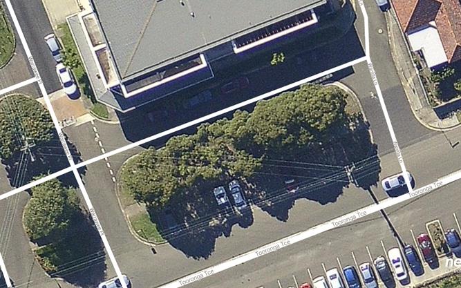
TAC058-14 Tooronga Terrace Beverly Hills - request for
additional parking spaces.
|
Report Author/s
|
Senior Traffic Engineer, Mrs S
Selim
|
|
File
|
14/763
|
|
Previous Reports Referenced
|
No
|
|
Community Strategic Plan Pillar
|
Social and Cultural Development
|
|
Existing Policy?
|
No
|
New Policy Required?
|
No
|
|
Financial Implications
|
Within Budget
|
EXECUTIVE SUMMARY
A
representation was received from Councillor Jack Jacovou, Mayor of Hurstville
City Council on behalf of the residents and shop owners of Beverly Hills,
requesting Council to provide additional parking spaces in Tooronga Terrace in
the vicinity of Beverly Hills shops.
|
AUTHOR
RECOMMENDATION
THAT the
existing parking arrangement outside IGA Supermarket in Tooronga Terrace,
Beverly Hills be changed as detailed below subject to consultation with the
affected shopkeepers in Tooronga Terrace, Beverly Hills:
· That the current ‘1P, 8.30am-6.30pm,
Mon-Fri, 8.30am-12.30pm, Sat’ zone be changed to ‘1/2P, 8.30am-6.30pm,
Mon-Sun’ zone.
· That 5 (half) of the existing 90
degree, ‘2P 8.30am-6.30pm, Mon-Fri, 8.30am-12.30pm, Sat’ parking spaces be
changed to ‘1P, 8.30am-6.30pm Mon-Sun’ zone.
· That the remaining 5 x 90 degree, ‘2P
8.30am-6.30pm, Mon-Fri, 8.30am-12.30pm, Sat’ be changed to ‘2P, 8.30am-6.30pm
Mon-Sun’ zone.
THAT a
detailed design and a Traffic Management Plan be prepared and brought back to
the Traffic Advisory Committee for the proposal to convert the road reserve opposite
IGA Supermarket, Beverly Hills into parking bays and restricting the laneway
adjacent to IGA Supermarket to one-way.
FURTHER
THAT Councillor Jacovou, Mayor of Hurstville City Council be advised of
Council’s decision.
|
REPORT DETAIL
A representation
was received from Councillor Jack Jacovou, Mayor of Hurstville City Council on
behalf of the residents and shop owners of Beverly Hills, requesting Council to
provide additional parking spaces in Tooronga Terrace in the vicinity of
Beverly Hills shops.
Recently, two
additional businesses were opened in the vicinity of IGA Supermarket in
Tooronga Terrace, Beverly Hills, increasing the demand for short term parking
in Tooronga Terrace Beverly Hills.
At present, 4
parallel parking spaces are available outside IGA Supermarket. These four
spaces are restricted to ‘1P, 8.30am-6.30pm, Mon-Fri, 8.30am-12.30pm Sat’.
Additionally, 10 x 90 degree angle parking spaces, restricted to ‘2P,
8.30am-6.30pm, Mon-Fri and 8.30am-12.30pm, Sat’ are available along the
northern side of Tooronga Terrace. Across the road, on the southern side of
Tooronga Terrace, in excess of 50 unrestricted 90 degree angel parking spaces
are available. Most of these parking spaces are utilised by rail commuters.
The residents
and shop owners in Beverly Hills have requested Council to consider the
following changes to the existing parking arrangement;
· That shorter term parking be introduced
to facilitate quick turnover of parking to service customers of IGA
Supermarket, who only require quick purchases
· That the parking restrictions be
extended to evenings and weekends
· That extra parking spaces be created
along the vacant land (road reserve) opposite IGA
· That the laneway outside IGA Supermarket
be converted to one-way
The current
nature of the shops in Beverly Hills require quick turnover of parking to allow
for more customers to frequent the businesses in Beverly Hills, and in addition
some of these businesses are open for later than 12.30pm on Saturdays and as
well as on Sundays.
Accordingly,
it is recommended implementing the following changes:
· That the current ‘1P, 8.30am-6.30pm,
Mon-Fri, 8.30am-12.30pm, Sat’ zone be changed to ‘1/2P, 8.30am-6.30pm, Mon-Sun’
zone.
· That 5 (half) of the existing ‘90
degree, 2P 8.30am-6.30pm, Mon-Fri, 8.30am-12.30pm, Sat’ parking spaces be
changed to ‘1P, 8.30am-6.30pm Mon-Sun’ zone.
· That the remaining 5 x 90 degree, ‘2P
8.30am-6.30pm, Mon-Fri, 8.30am-12.30pm, Sat’ be changed to ‘2P, 8.30am-6.30pm
Mon-Sun’ zone.
A
detailed design and a Traffic Management Plan will be prepared to examine the
feasibility of the residents’ request to make the laneway outside IGA
Supermarket one-way and provide additional parking within the road reserve
opposite IGA Supermarket. Present the detailed design and the Traffic
Management Plan to the Traffic Advisory Committee for consideration.
Hurstville City Council – Traffic Advisory Committee
Meeting Thursday, 5 June 2014
TAC059-14 Kingsgrove Car Park Kingsgrove - request for
parking changes
|
Report Author/s
|
Senior Traffic Engineer, Mrs S
Selim
|
|
File
|
14/380
|
|
Previous Reports Referenced
|
No
|
|
Community Strategic Plan Pillar
|
Environmental Sustainability
|
|
Existing Policy?
|
No
|
New Policy Required?
|
No
|
|
Financial Implications
|
Within Budget
|
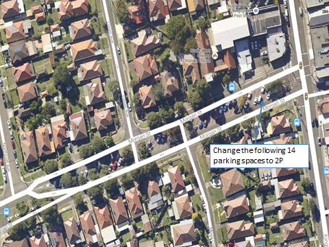
EXECUTIVE SUMMARY
Council has received a
representation from a business owner in Kingsgrove, requesting Council to
consider extending some of the 1 hour parking spaces in Morgan Street, Kingsgrove
to 2P.
|
AUTHOR RECOMMENDATION
THAT fourteen 45 degree angle
parking spaces in Morgan Street, west of Kingsgrove Road, Kingsgrove be
changed from 1P to ‘2P, 8.30am-6.30pm, Mon-Fri, 8.30am-12.30pm, Sat’.
FURTHER THAT the business owner
be advised of Council’s decision
|
REPORT DETAIL
Council received representation
from a business owner in Kingsgrove, requesting that Council consider extending
some of the parking spaces with 1 hour parking restrictions in Morgan Street,
Kingsgrove to 2 hours restriction.
Currently, there are 56 angled
parking spaces in the centre island of Morgan Street, west of Kingsgrove Road,
Kingsgrove.
42 of those parking spaces are
restricted to ‘1P, 8.30am-6.30pm, Mon-Fri, 8.30am-12.30pm, Sat’, while the rest
of the parking is unrestricted.
This parking area is divided into
three different sections with landscaped islands and access roadways.
The shop owner has advised that
as a business owner in the precinct she have noticed that there is surplus
parking available on most days and local businesses would benefit from patrons
having enough time to park, run their errands such as banking, post office and
then “linger” in the shopping centre. By providing longer parking time to
“linger”, customers can shop, have a coffee and lunch at the local cafe, walk
in to various businesses and enquire or make an appointment for services.
The shop owner has further
advised that the current reality is that there is a village like atmosphere in
Kingsgrove and everyone knows that the council parking officers are very active
and that almost everyone knows of somebody who has being booked for parking
over the 1 hour parking limit. As a result shoppers are so concerned that they
attend appointments and leave the shopping area as soon as possible.
Alternatively, some residents avoid the Kingsgrove Commercial Centre in fear of
being booked and opting to shop at Roselands or Hurstville.
Accordingly, the business owner
has requested Council to consider extending some of the 1 hour parking spaces
in Morgan Street to 2-hours to attract shoppers and encourage shoppers to stay
longer in the area.
It is advised that it is
beneficial to have a variety of time restriction in any shopping precinct to
cater for the needs of shoppers of different businesses. Accordingly it is
recommended to change 14 of the 1P parking spaces to 2P, leaving approximately
28 parking spaces as 1P.
With the proposed changes there
will be a provision of a variety of 1P, 2P and unrestricted parking in Morgan Street,
Kingsgrove.
It is further recommended that
the 14 spaces closest to Kingsgrove Road be the spaces that are to be changed
to 2P, 8.30am-6.30pm, Mon-Fri, 8.30am-12.30pm, Sat.
Hurstville City Council – Traffic Advisory Committee
Meeting Thursday, 5 June 2014
TAC060-14 Macmahon Street Car Park - Request to reserve
parking spaces for Sydney Polynesian Forum
|
Report Author/s
|
Senior Traffic Engineer, Mrs S
Selim
|
|
File
|
09/263
|
|
Previous Reports Referenced
|
No
|
|
Community Strategic Plan Pillar
|
Social and Cultural Development
|
|
Existing Policy?
|
No
|
New Policy Required?
|
No
|
|
Financial Implications
|
Nil
|
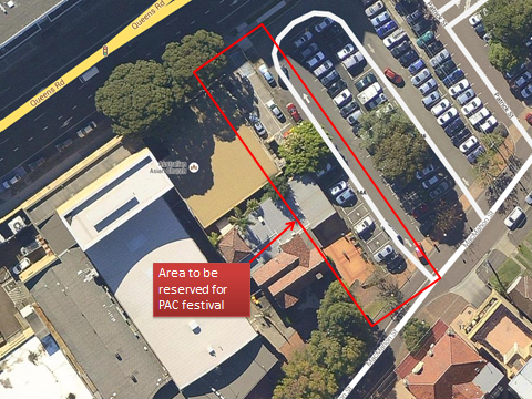
EXECUTIVE SUMMARY
Council’s Entertainment Section
has made a representation to Traffic Section requesting Council permission to
reserve some of the parking spaces at MacMahon Street car park to provide a
safe passage way for pedestrians between the Marana Auditorium and the Seniors
Citizens Centre for the Sydney Polynesian Forum. This event is scheduled to be
held in the Marana Auditorium on 2 August 2014. Entertainment Section also
proposes to utilise part of the car park to accommodate the over flow of stalls
of this event.
|
AUTHOR RECOMMENDATION
THAT the far west section (the
section adjacent to Council’s Museum) of MacMahon Street car park be reserved
for the Sydney Polynesian Forum on 2 August 2014.
FURTHER THAT Council’s
entertainment section be advised of Council’s decision.
|
REPORT DETAIL
Council’s Entertainment Section
has made a representation to Traffic Section requesting Council permission to
reserve some of the parking spaces at MacMahon Street car park to provide a
safe passage way for pedestrians between the Marana Auditorium and the Seniors
Citizens Centre for the Sydney Polynesian Forum. This event is scheduled to be
held in the Marana Auditorium on 2 August 2014. Entertainment Section also
proposes to utilise part of the car park to accommodate the over flow of stalls
of this event.
The Sydney
Polynesian Forum (the Forum) is a group of Community
& Education Representatives who have been meeting for the last two years to
network about Polynesian youth issues. To date they have identified a lack of
cultural identity and heritage being retained amongst Australian resident
Polynesian Youth that places them at risk of negative social outcomes.
Accordingly
the Forum has stepped into this gap and is part of the Sydney Polynesian
Australia Cultural Festival 2014, ‘Sydney PACFest 2014’. The aspiration of the
Forum is that such an event will be held annually and that it grows into other
Sydney regions.
The
Sydney Polynesian Forum booked the Marana Auditorium, Senior Citizens
Centre, the Civic Theatre and the HEC functions rooms on Saturday 2 August
2014, for their annual PAC festival. The event will entail the following
• An
event for School communities and their families to showcase, the wonderful
talent and pride of their Aboriginal and Polynesian students.
• Each
school will provide an Aboriginal/ Polynesian Performance Group, performing a
15min set.
• Performance set is to consist of songs and dance
representing Aboriginal (compulsory), Māori, Samoan, Tongan, Cook Island,
and Fijian cultures.
• The festival theme this year is “Building Unity.”
• Ten (10) schools/ school collectives are registered,
registration to perform is free.
• Tickets will be sold amongst participating schools
before the event.
• There will be food and retail/ information stalls set
up.
The concert will be held at the
Marana Auditorium and the Seniors Citizens Centre will be utilised for the
festival stalls.
This event will consist of local
and non-local schools performing, with guest of family and friends attending
the events. The event organisers are expecting more than 800 people to attend
these two venues on the day. Accordingly the festival organisers have
requested the use of the first part of Council’s car park to have a safe
passage way for pedestrians between the Marana Auditorium and the Seniors
Citizens Centre.
In addition to that, they would
like to have the over flow of stalls that cannot fit in the Seniors Centre to
be set up in the Car park area.
Hurstville City Council – Traffic Advisory Committee
Meeting Thursday, 5 June 2014
TAC061-14 Mulga Road Oatley - request for a loading zone
|
Report Author/s
|
Senior Traffic Engineer, Mrs S
Selim
|
|
File
|
12/1557
|
|
Previous Reports Referenced
|
No
|
|
Community Strategic Plan Pillar
|
Social and Cultural Development
|
|
Existing Policy?
|
No
|
New Policy Required?
|
No
|
|
Financial Implications
|
Within Budget
|
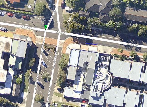
EXECUTIVE SUMMARY
Council has received a
representation from a small business owner at 47-67 Mulga Road, Oatley
requesting Council to consider installing a Loading Zone outside his business
premises for dropping off and picking up goods and deliveries.
|
AUTHOR RECOMMENDATION
THAT the existing 7.5m long No
Parking zone in Mulga Road, west of Woronora Parade, Oatley be changed to a
Loading Zone.
FURTHER THAT the business owner
be advised of Council’s decision.
|
REPORT DETAIL
Council has received a
representation from a small business owner at 47-67 Mulga Road, Oatley
requesting Council to consider installing a Loading Zone outside his business
premises for dropping off and picking up goods and deliveries.
It is advised that at present, a
30m timed Bus Zone exists outside the business complex at 47-67 Mulga Road,
Oatley. The bus zone is time restricted to operate between 7:00am-7:00pm,
Mon-Fri, 8:00am-6:00pm Saturday. At all other times on-street parking is
allowed and restricted to 1P. The 1P was introduced to provide extra quick
turnover of parking for businesses that are open later in the evenings and in
the weekends.
The business owner has requested
to shorten the Bus Zone to cater for a Loading Zone. The Bus Zone is 30m long.
Punchbowl Bus Company is the
operator that runs the bus services along Mulga Road, Oatley. Accordingly they
were consulted in regards to the Bus Zone and they have advised that this Bus
Zone is already the minimum length required for a Bus Zone and it cannot be
shortened.
It is further advised that the
subject business premises is located in an area with a variety of long term
on-street parking in the form of 2P parking and unrestricted parking. In
addition there is a 7.5m No Parking zone directly west of the business complex
where the business is located. This No Parking zone can be utilised to pick up
and drop off passengers and goods.
In February 2014 the Traffic
Advisory Committee considered the this matter and recommended:
“THAT the
request for a loading zone outside 47-67 Mulga Road, Oatley be deferred for
further investigation.
FURTHER THAT
the business owner be advised of Council’s decision”
The Traffic
Committee deferred this item to investigate the feasibility of changing the
existing No Parking zone at this location to a Loading Zone to support the
adjoining businesses.
Site investigation
and a meeting with the business owner on Mulga Road revealed that the existing
No Parking zone is ideal for the requested Loading Zone as it will provide a
safe area in Mulga Road for the local small businesses to load and unload their
goods.
Hurstville City Council – Traffic Advisory Committee
Meeting Thursday, 5 June 2014
TAC062-14 Gloucester Road, Pearl Street and Millet
Street Hurstville - Request for delineated car spaces
|
Report Author/s
|
Traffic Engineering Officer, Miss A
Kavanagh
|
|
File
|
11/729
|
|
Previous Reports Referenced
|
No
|
|
Community Strategic Plan Pillar
|
Economic Prosperity
|
|
Existing Policy?
|
No
|
New Policy Required?
|
No
|
|
Financial Implications
|
Within Budget
|
EXECUTIVE SUMMARY
A representation has received
from Councillor Jacovou, Mayor of Hurstville, requesting to consider delineating
on street parking spaces surrounding Hurstville Private Hospital on Gloucester
Road, Pearl Street and Millet Street, Hurstville.
|
AUTHOR
RECOMMENDATION
THAT the request for delineated car parking spaces on
Gloucester Road, Pearl Street and Millet Street, Hurstville be denied.
FURTHER THAT Councillor Jacovou, Mayor of Hurstville be
advised of Council’s decision.
|
REPORT DETAIL
Council has received a
representation from Councillor Jacovou, Mayor of Hurstville, requesting Council
to consider delineating on street parking spaces surrounding Hurstville Private
Hospital on Gloucester Road, Pearl Street and Millet Street, Hurstville.
Hurstville Private Hospital is
currently undergoing redevelopment including:
· Extension and
redevelopment of the Medical centre with a new story building, 2 levels of
basement parking and loading areas;
· Demolitions and
modifications to the existing hospital buildings;
· Bulk earthworks and
excavations;
· New and refurbished
basement car park;
· New floors over existing
Imaging Rooms and new adjacent stairs & lift to link to original
Administration building;
· Refurbishment of patient
wards;
· New signage on Pearl
Street frontage;
· New landscaping on Pearl
Street and Millett Street; and
· Public domain works including
footpaths, lighting and tree planting.
Currently Gloucester Road has a
91 metre 2P restriction on the western side of the road. Pearl Street has a
combination of “15 min”, “1P” and “2P” restrictions on the northern side
between Gloucester Road and Millett Street, Hurstville. Millet Street has a 40
metre Works Zone on the eastern side of the road. Otherwise, Millett Street
Hurstville is unrestricted. These restrictions have been provided to allow for
a high turnover of parking for patients and visitors to Hurstville Private
Hospital.
The hospital has requested to
delineate the car parking spaces on Gloucester Road, Pearl Street and Millett
Street to remind drivers to be considerate when parking.
Upon site inspection it was
evident that parking within these streets is in high demand and is heightened
at the moment due to three major construction sites being in such close
proximity to the hospital.
It is advised that there will be
a loss of available parking space, if all on-street parallel parking spaces are
delineated in accordance with the Australian Standards. The minimum length of a
marked parking bay according to the standards is 6.1m; but most of the cars in
the City are less than 4m long. Accordingly, if vehicles are parked in marked
parking bays, about 2m of space in between parked cars will be unused reducing
available parking spaces in a street by around 20 to 30%. For an example, if
parking bays are marked in the ‘91m long, 2P zone’ in Gloucester Road, only 15
cars can be legally parked within this zone. If the bays are not marked, the
same area can accommodate about 18 to 20 cars.
Additionally, this could set a
precedent, if on-street parking spaces are delineated in Gloucester Road, Pearl
Street and Millett Street and will have a significant burden on Council’s
traffic facilities budget, due to installation and maintenance cost.
Hurstville City Council – Traffic Advisory Committee
Meeting Thursday, 5 June 2014
TAC063-14 Millett Street Hurstville - Request for 90
degree angled parking
|
Report Author/s
|
Traffic Engineering Officer, Miss A
Kavanagh
|
|
File
|
11/729
|
|
Previous Reports Referenced
|
No
|
|
Community Strategic Plan Pillar
|
Economic Prosperity
|
|
Existing Policy?
|
No
|
New Policy Required?
|
No
|
|
Financial Implications
|
Within Budget
|
EXECUTIVE SUMMARY
A representation has received
from Councillor Jacovou, Mayor of Hurstville City Council requesting Council
investigate the feasibility of installing 90 degree angle parking on Millett
Street, Hurstville.
|
AUTHOR
RECOMMENDATION
THAT a feasibility study be
undertaken to examine the possibility of introducing a 90-degree angled
parking zone in Millett Street between Pearl Street and Ruby Street,
Hurstville.
THAT the outcome of the study
be reported to the Traffic Advisory Committee for consideration.
FURTHER THAT Councillor
Jacovou, Mayor of Hurstville City Council, be advised of Council’s decision.
|
REPORT DETAIL
A representation has received
from Councillor Jacovou, Mayor of Hurstville City Council requesting Council
investigate the feasibility of installing 90 degree angle parking on Millett
Street, Hurstville.
Hurstville Private Hospital is
currently undergoing redevelopment including:
· Extension and
redevelopment of the Medical centre with a new story building, 2 levels of
basement parking and loading areas;
· Demolitions and
modifications to the existing hospital buildings;
· Bulk earthworks and
excavations;
· New and refurbished
basement car park;
· New floors over existing
Imaging Rooms and new adjacent stairs & lift to link to original
Administration building;
· Refurbishment of patient
wards;
· New signage on Pearl
Street frontage;
· New landscaping on Pearl
Street and Millett Street; and
· Public domain works
including footpaths, lighting and tree planting.
Currently Millet Street has a 40
metre Works Zone on the eastern side of the road. Otherwise, Millett Street
Hurstville is unrestricted. Millet Street is approximately 12.25 metres wide
which would allow for 6 metres of parking and two traffic lanes of 3 metres.
The introduction of angled parking along Millet Street has the potential to
increase parking for residents, patients and visitors of Hurstville Private
Hospital.
Accordingly, it is considered
appropriate to prepare a detailed design to examine the feasibility of
introducing angled parking in Millett Street between Pearl Street and Ruby
Street, Hurstville.

Hurstville City Council – Traffic Advisory Committee
Meeting Thursday, 5 June 2014
TAC064-14 Lugarno Lions Spring Festival 2014 - Proposed
Traffic Control Measures
|
Report Author/s
|
Traffic Engineering Officer, Miss A
Kavanagh
|
|
File
|
14/898
|
|
Previous Reports Referenced
|
No
|
|
Community Strategic Plan Pillar
|
Economic Prosperity
|
|
Existing Policy?
|
No
|
New Policy Required?
|
No
|
|
Financial Implications
|
Within Budget
|
EXECUTIVE SUMMARY
Council has received representations from the Lions Club of Lugarno,
advising that the Lugarno Lions 35th Spring Festival at Gannons
Park, Peakhurst will be held on Sunday, 21 September 2014. To facilitate this
event, the Lions Club of Lugarno has requested Council's approval to establish
a number of traffic control measures to regulate traffic flow on the adjoining
road network during the event.
|
AUTHOR
RECOMMENDATION
THAT
Hurstville Council install the following temporary traffic control measures
on Sunday 21st September, 2014 to facilitate the 2014 Lugarno Lions Spring
Festival at Gannons Park, Peakhurst:
1. Install a temporary "No Right Turn"
restriction on Forest Road at Boatwright Avenue, Peakhurst to restrict
westbound traffic on Boatwright Avenue from turning right into Forest Road,
Peakhurst.
2. Install a temporary "No Right Turn"
restriction on Isaac Street at Pindari Road, Peakhurst to restrict northbound
traffic on Pindari Road from turning right into Isaac Street, Peakhurst.
3. Install a temporary "No stopping"
restriction in Boatwright Avenue from Forest Road to the southern side of the
main entrance of Gannons Park, Peakhurst.
4. Install a temporary "No Parking"
restriction on both sides of Boatwright Avenue, Bottlebrush Avenue and Ernest
Street, Peakhurst to clear on-street parking in these streets to improve
traffic flow in the area.
5. Install a temporary "No Stopping"
restriction in Isaac Street from Forest Road to Pindari Road, Peakhurst.
6. Install temporary “one way” signs in a southerly
direction at the northern entrance of Jindabyne Cres., at the intersection of
Pindari Road, Peakhurst Heights and “One Way No Entry” signs at the
intersection of Jindabyne Crescent and Whitegates Avenue, Peakhurst Heights
to make Jindabyne Crescent one way in a southerly direction from house
numbers 1 to 21 and 2 to 14.
THAT bus
operators be notified of the proposed traffic management measures.
THAT a
Traffic Management Plan (TMP) be submitted to the RMS and Police for the
proposed traffic management measures.
FURTHER THAT the Lions Club of
Lugarno be notified of Council's decision.
|
REPORT DETAIL
Lugarno Lions Spring Festival is an annual event organised by the Lions
Club of Lugarno during early spring each year. Last year this event attracted
in excess of 45,000 people and the traffic was managed with no reported
incidents with the assistance of the Hurstville SES and Police.
This year, the 35th Spring Festival of Lugarno Lions Club is
planned to be held at Gannons Park, Peakhurst on Sunday, 21 September
2014. The organisers of this event have requested Council support to implement
the following traffic management measures for the day of the event to assist
managing traffic in the area:
- A temporary "No Right Turn" restriction on
Forest Road at Boatwright Avenue, Peakhurst to restrict northbound traffic on
Forest Road from turning right into Boatwright Avenue, Peakhurst.
- A temporary "No Right Turn" restriction on
Isaac Street at Pindari Road, Peakhurst to restrict northbound traffic on
Pindari Road from turning right into Isaac Street, Peakhurst.
- A temporary "No stopping" restriction in
Boatwright Avenue from Forest Road to the southern side of the main entrance of
Gannons Park, Peakhurst.
- Temporary "No Parking" restrictions on
both sides of Boatwright Avenue, Bottlebrush Avenue and Ernest Street,
Peakhurst to clear the parking in these streets to facilitate easier traffic
access in the area.
- A temporary "No Stopping" restriction on
Isaac Street from Forest Road to Pindari Road, Peakhurst.
- Install temporary “one way” signs in a southerly
direction at the northern entrance of Jindabyne Cres., at the intersection of
Pindari Road, Peakhurst Heights and “One Way No Entry” signs at the
intersection of Jindabyne Crescent and Whitegates Avenue, Peakhurst Heights to
make Jindabyne Crescent one way in a southerly direction from house numbers 1 to
21 and 2 to 14.
In the past few years Council has approved the similar traffic control
measures to ensure unhindered traffic flow surrounding Gannons Park during the
event. This year in addition to traffic management measures implemented in the
past, the Lugarno Lions Club would like to address the traffic congestion on
the eastern side of the park by changing Jindabyne Crescent to one way from
Pindari Road in a southerly direction to the intersection of Whitegates Avenue
and open the Jindabyne Crescent gate to the bike track, as a public parking
entry point to the middle portion of Gannons Park. The Lugarno Lions Club has
provided Council with a petition signed by all residents in the affected
portion of Jindabyne Crescent, agreeing to the proposal.
Car parking will be provided within the middle part of Gannons Park,
between Ernest Street and Kara Lane, to accommodate an overflow of public
parking. Event organisers have made arrangements to provide a shuttle bus
service to transport people between the upper park and the festival site.
In addition, subject to weather conditions, the Lions Club has made
arrangements to utilise Peakhurst High School and Catholic Church grounds to
provide additional off street parking facilities. The Lions Club has advised
that Hurstville SES has agreed to provide SES volunteers to manage traffic,
parking and crowds both on and off the park during the event. The Club has
requested the Police assistance (as in the previous years) to manage traffic in
the adjoining road network.

Hurstville City Council – Traffic Advisory Committee Meeting
Thursday, 5 June 2014
TAC065-14 Wonoona Parade Oatley - Request for a No
Parking restriction
|
Report Author/s
|
Traffic Engineering Officer, Miss A
Kavanagh
|
|
File
|
13/1023
|
|
Previous Reports Referenced
|
No
|
|
Community Strategic Plan Pillar
|
Economic Prosperity
|
|
Existing Policy?
|
No
|
New Policy Required?
|
No
|
|
Financial Implications
|
Within Budget
|
EXECUTIVE SUMMARY
Council has received a
representation from the residents of Number 2A and 4 Wonoona Parade West,
Oatley requesting Council to consider installing a No Parking restriction
between the driveways of the subject properties.
|
AUTHOR
RECOMMENDATION
THAT Council install a 17 metre
long No Parking restriction over the driveways of property Numbers 2A and 4
Wonoona Parade West, Oatley.
FURTHER THAT the residents be
advised of Council’s decision.
|
REPORT DETAIL
Council has received a
representation from the residents of Number 2A and 4 Wonoona Parade West,
Oatley requesting Council to consider installing a No Parking restriction
between the driveways of the subject properties.
The residents state that as a
result of increased use at Oatley train station vehicles parking in the
vicinity of the station has increased. The residents explain that they have
difficulties reversing out of their driveways and usually have to cross the
double centrelines when a vehicle is parked in the 3.5 metre area between the
driveways of the subject properties.
Accordingly it is considered
appropriate to install a No Parking restriction over the driveways and kerb
space between the driveways of 2A and 4 Wonoona Parade, Oatley.
Hurstville City Council – Traffic Advisory Committee
Meeting Thursday, 5 June 2014
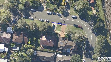
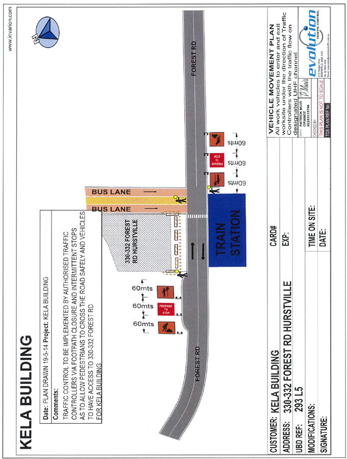
TAC066-14 330-332 Forest Road Hurstville - Request for
Road Closure
|
Report Author/s
|
Traffic Engineering Officer, Miss A
Kavanagh
|
|
File
|
14/35
|
|
Previous Reports Referenced
|
No
|
|
Community Strategic Plan Pillar
|
Economic Prosperity
|
|
Existing Policy?
|
No
|
New Policy Required?
|
No
|
|
Financial Implications
|
Within Budget.
|
EXECUTIVE SUMMARY
Council has received an
application from the developer of 330-332 Forest Road, Hurstville requesting
Council permission to close Stand ‘A’ of the Hurstville Transport Interchange
to stand a mobile crane and close Forest Road intermittently to allow truck
access to the development site.
|
AUTHOR
RECOMMENDATION
THAT the proposed closure of
Stand ‘A’ of the Hurstville Transport Interchange and the proposed
intermittent closure of Forest Road adjacent to 330-332 Forest Road,
Hurstville be approved subject to the conditions included in the report.
FURTHER THAT the applicant be
notified of Council’s decision.
|
REPORT DETAIL
Council has received
representations from the developer of 330-332 Forest Road, Hurstville, KELA
Building Group Pty Ltd requesting Council permission to:
· Close Stand ‘A’ of the
Hurstville Transport Interchange to stand a crane to swing material over public
land into the construction site located at 330-332 Forest Road, Hurstville.
· Provide vehicle access to
330-332 Forest Road Hurstville over Council’s footpath in Forest Road,
Hurstville for removal of debris during the demolition stage and the delivery
of construction materials during the construction stage. The developer is
planning to complete all the renovation works within a period of 4-months.
The applicant is in the process
of seeking a Road Occupancy License (ROL) from the Road and Maritime Services
for the proposed occupancy of road related area as the proposed road closures
are in the vicinity of the existing traffic lights at the Hurstville Transport
Interchange. Council permits will only be issued subsequent to a copy of the
license being forwarded to Council’s Traffic Section.
The developer has proposed
following activities on Council’s road related area during the construction
period:
· Stand a crane adjacent to
Stand A of the Hurstville Transport Interchange to unload material (swing
material over Public land) to the construction site. The developer has advised
that this activity will take place about 6-occasions during the 4-month
renovation period.
· Intermittent closure of
Forest Road and the footpath adjacent to 330-332 Forest Road, Hurstville to
provide truck access to the development site over Council’s footpath. Forest
Road and the footpath will need to be closed for about 2-minutes each time a
truck access the site. The developer has advised that approximately 6-truck
(12 trips) will access the site during the demolition stage and about 1 to 2
trucks will access the site during the construction stage. The trucks will be
5-tonne (small) rigid trucks. As detailed in the attached Traffic Control Plan,
the developer is proposing to engage three RMS accredited traffic controllers
to control traffic and pedestrians each time a truck needs to access or leave
the site.
It is recommended to approve the
proposed road closures subject to following conditions:
1. Obtain Road Occupancy Licences from the
Transport Management Centre (TMC) for the proposed occupancy of Stand ‘A’ of
the Hurstville Transport Interchange and Forest Road, Hurstville. The TMC
can be contacted on 131 700 or http://www.transport.nsw.gov.au/tmc.
2. The occupancy (closure) of Stand ‘A’ of the
Hurstville Transport Interchange is allowed only during night time between the
hours of 10pm and 5am. At all times, Stand ‘B’ of the Hurstville Transport
Interchange shall be open for through bus
traffic.
3. The applicant shall notify the Bus Operators
in advance (at least 48 hours in advance) each time the Stand ‘A’ of the
Hurstville Transport Interchange is occupied during the night time.
4. Temporary access
over Council’s paved footpath at 330-332 Forest Road, Hurstville (intermittent
closure of Forest Road) is allowed only between 9:00am and 3:00pm, Monday to
Saturday.
5. Safe pedestrian access along Forest Road and at Hurstville Transport Interchange shall be maintained at all
times. Traffic Control Measures shall be provided to maintain public safety
for pedestrians, workman and other road users, to the satisfaction of Council’s
Traffic Engineering Section. Such devices shall comply with the requirements
of AS 1742, ‘Australian Standard Manual of Uniform Traffic Control Devices’.
6. Forest Road,
Hurstville shall be open
for through traffic at all times with appropriate traffic control measures.
7. Only RMS accredited traffic control
personnel shall be used to control pedestrian and traffic flow around the work
site at all times.
8. The requirement of the Local Government Act
1993, Regulations, Council’s Local Approvals Policy and adopted codes prevail
and shall be fully complied with.
9. Appropriate Stormwater Protection Measures
shall be provided to ensure the gutters are kept clear of obstructions at all
times. The applicant shall be responsible to ensure all appropriate erosion and
sedimentation control measures are installed prior to the occupation of Council
road and road related area (footpath, nature strip etc) and remain effective
throughout the construction period.
10. Under all circumstances, access for emergency
vehicles shall be provided during the use of Council road and/or road related
area.
11. Care must be taken to protect Council’s
property, including the road pavement, man made footway, kerb and guttering
during the use of Council road related area. Any damage to Council’s road
including the footway, kerb and guttering will be repaired and the full cost
shall be borne by the applicant. In this regard applicant is required to make
a payment of a damage deposit to Council amounting to $20,000. The damage
deposit will be refunded in full upon completion of the works where no damage
occurs and where Council is satisfied with the completion of works.
Alternatively, the damage deposit will be forfeited or partly refunded based on
the damage incurred.
12. The applicant or it’s agent shall be insured
against public liability amounting to $10,000,000 during the duration of the
work and shall show proof that such a policy is effective prior to the use of
Council’s road related area.
6. General
Business
7. Next Meeting
Next Meeting Date Thursday 03 July 2014 at 1:00pm